Wednesday, February 9, 2022

The Hydrology Class 2022 - The schedule

This post contains the foreseen schedule of the course. Material uploaded is subject to modifications prior to the schedule date. All the lectures will be to students present in blended format. Meaning that students can be either present or attend remotely. All of them will be recorded and uploaded to web. 


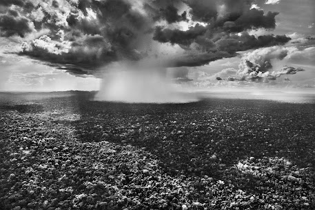
Photo by Michele Vettorazzi


Topics in bold are definitive. Topics in normal characters are still subject to modifications.  All the 2022 videos will be available at this Vimeo Showcase.

2022-02-21 - Introduction to the course and to hydrology

Complementary References

2022-02-22  - Ground based Precipitations and their statistics Separation snow-rainfall - measure of precipitation

In this part of the class we describe where it rains and how much it rains using statistical concept. One important objective is to understand what are the extreme precipitations for their importance in engineering. 
2022-02-28 - 2022-03-01  - Statistics of extreme precipitations

 Some reviews on statistics - Return Period
Extreme precipitations  (Storyboard2020)
Distributions Storyboard2020

Determination of Gumbel's parameters
Extreme precipitations  II
Beyond Gumbel
A summary about the extreme precipitation estimations (Whiteboard)

2022-03- 07 - Water in soil and aquifers. Darcy-Buckingham. Hydraulic conductivity. Soil water retention curves (Storyboard2020)

Once precipitations arrive to the ground surface they either infiltrate or generate runoff. We first state how they infiltrate and, actually how water behave in the soil and in the ground. We talk about the complexity of the Earth surface that contains life and call it, the Critical Zone. To study infiltration we introduce the Darcy and Richards equations of which we explain the characteristics. 
2022-03-08
2022-03-14

2022 - 03- 15 
- The Richards equation  (Storyboard 2020)
2022-03-21
    2021-03-28 - Runoff Generation and propagation (Summary 2020)

    Once the rainfall gains the terrain, it can infiltrate or producing runoff. In the next we discuss the main mechanisms that produce runoff.
    Q&A - Runoff - Runoff 2022

    2020-03-29 - The surface water propagation (a brief Storyboard 2021)

    Runoff moves on the surface of the terrain according to the de Saint-Venant equation. In the following the equation is derived in the 1D case.
    2022-04-04/05

    Evaporation generalities 
    (Storyboard2020)

    A consistent part of root zone and surface water evaporates and returns to the atmosphere to eventually form clouds and precipitation again. The process follows quite complicate routes and is different when happening from liquid surfaces, soil or vegetation (and BTW animals).  In this group of lectures we try to figure out the physical mechanisms that act in the process and give some hint on methods to estimate evaporation and transpiration with physically based models. 
     Evaporation and Transpiration Formulas
    2022-04-12 -  After all radiation moves it all

    The Hydrology Class 2022 - Introduction


    What the Hydrology Course is About


    To have an idea about this class, please look at the Syllabus  slides in first lecture.  This year the class will be 90% similar to the one of the last year.  Laboratory work will be (mostly) concentrated in May and June. March and April up to Easter will be mostly spent to develop the theoretical parts.
    Lectures  and lab classes will be recorded and uploaded on my VIMEO channel. Old videos are also in my on my YouTube channel.

    The intermediate exam will be written (or oral *) with 3 questions about the topics treated.  The students will be asked to answer with text, figures and formulas. The final exam will be a discussion of the exercises provided by the students int the form of Jupyter notebooks. Each of the exercises will be discussed separately by booking an appointment with the professor before the formal date of the exam or at the day of the final exam. 

    This Hydrology class aims to explain the physics (meaning the mathematical equations and their phenomenology) and, in some cases, the statistics (i.e. the distribution) of the basic hydrological processes (precipitation, runoff, infiltration, evaporation and transpiration)
    Students will be required to:
    •  being able to derive and comment the hydrological equations above mentioned and 
    • to do some statistics on hydrological data. Particular attention will be dedicated to the derivation of the statistics of extreme rainfall.
    • Besides students will be requested to get some basics of the tools that will be used to estimate the hydrological fluxes (using a GIS, Python, and other tools, among those in GEOframe).
    They will be required to be able, by means of some models provided by the instructors the main hydrological fluxes and represent them at catchment scale.

    This is intended to serve as a basis for getting further knowledge and
    • prevent, manage, control floods, landslides and snow-avalanches
    • manage irrigation
    • estimate water availability for hydropower production
    • forecast roads freezing
    • estimate soil, roads, or snow temperature
    • forecast snow water equivalent and snow height
    Assuming that the student will take a master in Environmental Engineering at Trento University, Acquedotti e fognature, Modelli idrologici, Ingegneria fluviale, are classe that request the knowledge communicate in this Hydrology class. 

    The first part of the course, until April 3, will be dedicated to the presentation and discussion of theoretical concepts through lectures that will be videotaped and uploaded on the course's Vimeo channel. The lessons will cover 4 of the five hours per week. The fifth hour will be devoted to simple exercises with Python and Jupyter lab and to the preparation of the data necessary for the projects to be completed in the second part of the course in groups of two or three students.
    The student must take care to understand the hydrological concepts and discuss them with the lecturer. The first twenty minutes of each lesson will be devoted to the discussion of the topics covered in the previous lesson. Each group will have to prepare one question or comment to which the teacher will answer. A summary of the lesson will follow, followed by the actual lesson. The second part of the course will take up the theoretical themes of the first part and using the tools made available to the GEOframe system. Students, in groups of two or three, will have to:

    • Analyze a series of rainfall and hydro-meteorological data with the use of Python 
    • Estimate the intensity-duration-frequency curves with the methods presented in the first part of the course using the data of a hydro-meteorological gauge station
    Besides, they have to accomplish two of the following three tasks under the supervision of the tutor and the teacher: 
    • Design and run some infiltration simulations in complex soils and discuss the results.
    • Design and perform the calculation of evaporation and transpiration in a chosen site
    • Studying the coupled transpiration and infiltration in one site. 
    * The exam will be written if COVID-19 will allow the students to be in classroom. Otherwise it will be oral. 

    References

    The lessons will be video recorded and made available. Each lesson will be given through slides in English which will be delivered to students in advance. When necessary, the lessons will be accompanied by appropriate in-depth articles. There is no real text because the course, even when it is fully in the hydrological tradition, elaborates the concepts in a contemporary way and uses innovative tools.

    As general reference texts we recommend:
    • Bras, R.L, An introduction to Hydrologic Science, ISBN-13: 978-0201059229, 1989 - ISBN-10: 0201059223, Addison-Wesley (July 1, 1989)
    • Brutsaert, W., Hydrology: an introduction, ISBN-13: 978-0521824798 - ISBN-10: 0521824796, Cambridge University Press, 2005
    • Dingmann, L., Physical Hydrology, ISBN-13: 978-1478611189, ISBN-10: 1478611189, Third Edition, Waveland Press, 2015
    • Freeze, A. ; Cherry, J., Groundwater, 1979
    • Lu, N. and Godt, J.W., Hillslope Hydrology and Stability, Cambridge University Press, ISBN-13: 978-1107021068, ISBN-10: 11070210652010, 2013

    These books represent a shareable review of phenomena and hydrological modeling but the methods they present are not necessarily those used in the course. The course, also for reasons of time, presents a selected and limited perspective of the subject that the texts cited dissect from various points of view.

    Friday, January 21, 2022

    Seven Steps in Modelling a Catchment - Reprise

     Recently I delivered a post where I discussed the the steps in doing a catchment analysis, based on the previous recent experiences on the topic.  The seven steps are in brief:

    1. Clarify the scope of your analysis and gather the information
    2. Analyse the catchment geomorphology
    3. Analyze all the available data
    4.  Make the simulations plan and setting up the simulations 
    5. Running the simulations
    6.  Showing and discussing the results and their reliability
    7.  Deploy all what done for Open Science


    Another step, actually is building or choosing  the model, which previously was given for granted (so actually the 7 steps can be 8 but this obviously does not really matters. During the GWS2022 I went further in developing a presentation in three parts and I deployed it, 


    Sunday, January 9, 2022

    WHETGEO essentials

    Water, HEat and Transport in GEOframe  (WH?ETGEO) is the set of components which was conceived and developed to substitute GEOtop. It with GEO-SPACE more precisely. Its design is more complex than GEOtop, since it includes various modelling solutions, 1D, 2D, 3D (coming soon) and additional processes can be added without large efforts. 2D and 3D versions can work with an unstructured grids and there is a lot of flexibility to be exploited to pursue new ideas that were not even conceivable with GEOtop. 


    At present the best presentations of the models and the ideas are obtained by reading the Niccolò Tubini Ph.D. Thesis and the paper on GMD just published. WHETGEO + GEOSPACE have a dedicated summer school whose 1st edition was celebrated recently.  The index of GEOframe Schools can be found here.

    Other contributions will come soon. 

    References

    Tubini, N. 2021, June. “Theoretical and Numerical Tools for Studying the Critical Zone from Plots to Catchments.” Edited by R. Rigon and S. Gruber. Ph.D., Dipartimento di Ingegneria Civile, Ambientale e Meccanica, Università di Trento.

    Tubini, Niccolò, and Riccardo Rigon. 2022. “Implementing the Water, HEat and Transport Model in GEOframe (WHETGEO-1D v.1.0): Algorithms, Informatics, Design Patterns, Open Science Features, and 1D Deployment.” Geoscientific Model Development 15 (1): 75–104. http://dx.doi.org/10.5194/gmd-15-75-2022

    Tuesday, December 28, 2021

    Edward Wilson (1929-2021) - A storm in the Amazon

    From "The diversity of life" 

    "I sorted the memories this way and that in hope of stumbling on some pattern not obedient to abstract theory of textbooks. I would have been happy with any pattern. The best of science doesn't consist of mathematical models and experiments, as textbooks make it seem. Those come later. It springs fresh from a more primitive mode of thought, wherein the hunter's mind weaves ideas from old facts and fresh metaphors and the scrambled crazy images of things recently seen. ...


    The storm grew until sheet lightning spread across the western sky. The thunderhead reared up like a top-heavy monster in slow motion, tilted forward, blotting out the stars. The forest erupted in a simulation of violent life. Lightning bolts broke to the front and then closer, to the right and left, 10,000 volts dropping along an ionizing path at 800 kilometers an hour, kicking a countersurge skyward ten times faster, back and forth in a split second, the whole perceived as a single flash and crack of sound. The wind freshened, and rain came stalking through the forest. In the midst of chaos something to the side caught my attention. The lightning bolts were acting like strobe flashes to illuminate the wall of the rain forest. At intervals I glimpsed the storied structure: top canopy 30 meters off the ground, middle trees spread raggedly below that, and a lowermost scattering of shrubs and small trees. The forest was framed for a few moments in this theatrical setting. Its image turned surreal, projected into the unbounded wildness of the human imagination, thrown back in time 10,000 years. Somewhere close I knew spear-nosed bats flew through the tree crowns in search of fruit, palm vipers coiled in ambush in the roots of orchids, jaguars walked the river's edge; around them eight hundred species of trees stood, more than are native to all of North America; and a thousand species of butterflies, 6 percent of the entire world fauna, waited for the dawn.

    …..

    The storm arrived, racing from the forest's edge, turning from scattered splashing drops into sheets of water driven by gusts of wind. It forced me back to the shelter of the corrugated iron roof of the open-air living quarters, where I sat and waited with the mateiros. The men stripped off their clothing and walked out into the open, soaping and rinsing themselves in the torrential rain, laughing and singing. In bizarre counterpoint, leptodactylid frogs struck up a loud and monotonous honking on the forest floor close by. They were all around us. I wondered where they had been during the day. I had never encountered a single one while sifting through the vegetation and rotting debris on sunny days, in habitats they are supposed to prefer. "

    Edward O. Wilson, The Diversity of life, Penguin

    Monday, December 27, 2021

    DARTH4MED - A Digital eARth Twin of Hydrology for the prediction of water scarcity in the Mediterranean area


    The DARTH4MED, D4M for short, project aims to be a high resolution twin of the hydrology and carbon cycle of the Italian peninsula. It is based on Po, WATZON and WATERSTEM projects, making treasure of previous modelling efforts like GEOtop and the GEOframe system, and GIS tools implementations like Jgrass and the Horton Machine toolbox. It builds upon state-of-art hydrological modelling case studies of various catchment sizes, from hillslope to Po and Blue Nile. It also draws on experiences in IT applied to hydrology with developments of the object modelling system, OMS.

    D4M gives substance, both technical and scientific, to the Digital Earth metaphor and exploits it to improve the work of scientists and professionals, and to support open science. It aims to provide a shared infrastructure usable by scientists and users to investigate the processes involved in the water, energy and carbon budgets, WB, EB and CB, at a very fine spatial and temporal scale, 1 km2, hourly.

    The GEOframe system already contains a sophisticated and complete set of modelling components, constituting a solid basis of comparison for innovative developments. Open API and training will be offered to anyone to advance the mathematical, statistical and numerical descriptions of hydrological and eco-hydrological processes with little programming effort. From this perspective, the project will be an experiment in participatory science, since the tools developed could be improved and given back by collaborative researchers. The method of multiple hypothesis testing will be the rule of scientific endeavour.

    The core of the system will manage the interactions of groundwater, vadose zone, surface water, snow, vegetation, atmosphere, usually analyzed separately, and join them seamlessly in the continuum containing the feedbacks among the parts. On these bases researchers will be able to evaluate climate, hydrologic, pedological, ecological droughts.


    D4M has several primary objectives, listed below:
    • To provide the core of a DE, defined as a Digital eARth Twin Hydrology system (a DARTH), to do hydrology by computer, with an infrastructure that allows partecipative hydrology and makes Earth system science practice easier for all the Italian Peninsula.
    • To improve the modelling of the water budget, WB, energy budget, EB, Vegetation and Carbon Cycle.
    • To provide forecasts for several variables, as detailed in the Synopsis.
    • To resolve some research questions, as presented in the Synopsis.
    • To give researchers sound tools on which to base their analysis of climate, hydrologic, pedological, ecological and agronomic droughts.
    • To provide a high level of abstraction and encapsulation for modelling services, so to allow improvements to parts of the DARTHs by anyone without disrupting the whole.
    • To give API and web services to final users, researchers, technical professionals, programmers, to connect their studies and products to the whole D4M, thus combatting the fragmentation of hydrological modelling through a participatory open platform.
    Besides efficient algorithms, the effort will require the smart implementation of parallel computing infrastructures, which will remain mostly invisible to the users. All the infrastructure will be open source, built with open source tools and provided with open data.

    The project was just submitted for the FIS call. Here below you find the proposal and the relevant annexes.
    Compressing all the ideas in such a few words was quite difficult and the platform on which we had to upload the material with some issues (non accepting, for instance "()[]-/" and other characters. Some requirements quite stupid. The selection will be great. I obviously think that the gain for the country with such a project really great. Finger crossed and, if there are better projects, hope they'll win. 

    Wednesday, December 15, 2021

    DARTHs (Digital eARth Twin Hydrology systems)

    There is a great hype about Digital Earth Twins (DETs) and EU, ESA, NASA and other institutions issue calls for building such IT infrastructures (ITI). This paper face the topic from a point of view of hydrologists who are concerned with the science content of these ITI. The Authors see in DETs an opportunity to make easier the work of scientists and professionals. However they claim that some aspect of making science should be respected. Mainly they are the hypothesis testing and estimation of errors in hindcasting or forecasting. Beside, the Authors claim that building a DET for Hydrology (called DARTH) is an enterprise that implies some choices about the implementation of models and of the infrastructure. DARTHs are not in fact just "models" and have requirements that need to be satisfied. Finally the Authors support the opinion of an open science oriented implementation of these ITI that also allows the participatory action of all the scientists that like to contribute (and look with suspect to science processing where just a few contribute to the core science). In turn also this options has requirements that should be reflected in the implementation.
    To sum up, the Authors think that this is the right moment to push these ideas and desire to open a discussion with other colleagues. 

    Final published paper: 


    You can find the manuscript submitted to HESS discussions HESSD at the moment in our OSF repository, here.  

    UPDATE: The paper had a positive first round of reviews that you can see here.  Below, please find the revised text with the supplemental material. 

    Final published paper: