Showing posts with label Luca Brocca. Show all posts

Friday, November 13, 2020

Earth Observation For Water Cycle Science 2020

 I receive from Luca Brocca and I think the topic is interesting and the project mentioned worth to be followed. 

Dear colleagues


we have organised a discussion session at ESA conference EO FOR WATER CYCLE SCIENCE 2020  on Digital Twin Earth Hydrology (DTE Hydrology).
DTE Hydrology is a very recent activity (started one month ago) that aims at building an integrated and interactive system providing the best possible reconstruction and simulations of the water cycle and the hydrological processes and its interactions with human activities at unprecedented resolutions and accuracies (see also here for more information). The first implementation of DTE Hydrology will be carried out over the Po River Basin.

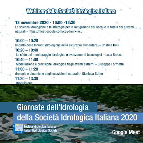
The session is on Tuesday 17 November 15:00-16:30 (UTC+1) (here the agenda).  The general agenda is obtained by clicking the image above.

Saturday, January 10, 2015

Matching process based modelling and remote sensing

This blog post summarizes a recent discussion I have had with Luca Brocca concerning the use of remote sensing data in hydrological applications. As you know, I have expertise on the description of the hydrological processes and on the development/implementation of physically-based hydrological models (i.e., GEOtop [1,2]). Luca has experience on the use and assimilation of remote sensing products of soil moisture and rainfall into hydrological model for improving hydrological predictions (e.g. flood [3] and landslide [4] forecasting).

Our starting viewpoints on remote sensing products are quite dissimilar. Luca has a lot of confidence on satellite data and he found in his research activity that remote sensing could be highly important for improving the modelling and prediction of hydrological processes (see, e.g., his recent interview on Research Gate and [5]). On my side, I believe that remote sensing products are derived from sensors data without strong reference to reasonable hydrological modelling. In fact, most of the times, remote sensing products are not the results of assimilation (or fusion) of data with hydrological models, but the outcome of procedures that may involve strong hydrological assumptions that remain implicit. This in my view constitutes a bad practice and a source of large mismatching between the results of the two communities.

In a recent post, it is highlighted how even physically-based and fully 3D hydrological models may fail in reproducing the spatial variability of soil moisture (e.g., [6]), and similar results were found in the comparison of satellite and modelled soil moisture data (e.g. [7]). Studies that attempted to used satellite rainfall data as input (see in [8]) or assimilated satellite soil moisture data [9] into rainfall-runoff models usually found several issues that still need to be addressed.

These issues can be addressed in two ways. I told Luca that a model of the sensor should be available from the side of the hydrological models, in which the process-based models can give all the information necessary to reproduce the expected results as seen from the sensors. In this way, a more direct assimilation could be made without undeclared passages that introduce bias in the products. Luca replied on the need to improve the structure of conceptual hydrological models (usually employed in most of the studies) to better fit what is measured from satellite sensors (see the discussion paragraph in [3]). In both cases, we are suggesting that the two communities, hydrologists and remote sensing scientists, should start a stronger and closer collaboration. It should not happen that hydrologists use satellite data simply as end-user without giving feedback to remote sensing scientists, and viceversa remote sensing scientists should take care of the suggestions and criticism made by hydrologists. From the close collaboration both communities can highly benefit providing improved models and satellite products each other!

REFERENCES

[1] Rigon, R., Bertoldi, G., and T.M. Over,  GEOtop: A distributed hydrological model with coupled water and energy budgets, Jour. of Hydrommet. , 7(3), 371-388, 2006

[2] Endrizzi, S., Gruber, S., Dall'Amico, M., and Rigon, R. (2014). GEOtop 2.0: simulating the combined energy and water balance at and below the land surface accounting for soil freezing, snow cover and terrain effect. Geosci. Model Dev., 7, 2831-2857, doi:10.5194/gmd-7-2831-2014.

[3] Brocca, L., Moramarco, T., Melone, F., Wagner, W., Hasenauer, S., Hahn, S. (2012). Assimilation of surface and root-zone ASCAT soil moisture products into rainfall-runoff modelling. IEEE Transactions on Geoscience and Remote Sensing, 50(7), 2542-2555, doi:10.1109/TGRS.2011.2177468.

[4] Brocca, L., Ponziani, F., Moramarco, T., Melone, F., Berni, N., Wagner, W. (2012). Improving landslide forecasting using ASCAT-derived soil moisture data: A case study of the Torgiovannetto landslide in central Italy. Remote Sensing, 4(5), 1232-1244, doi:10.3390/rs4051232.

[5] Brocca, L., Ciabatta, L., Massari, C., Moramarco, T., Hahn, S., Hasenauer, S., Kidd, R., Dorigo, W., Wagner, W., Levizzani, V. (2014). Soil as a natural rain gauge: estimating global rainfall from satellite soil moisture data. Journal of Geophysical Research, 119(9), 5128-5141, doi:10.1002/2014JD021489.

[6] Cornelissen, T., Diekkrüger, B. Bogena, H.R. (2014). Significance of scale and lower boundary condition in the 3D simulation of hydrological processes and soil moisture variability in a forested headwater catchment. Journal of Hydrology, 516, 140-153, doi: 10.1016/j.jhydrol.2014.01.060.

[7] Li, B. and Rodell, M. (2013). Spatial variability and its scale dependency of observed and modeled soil moisture over different climate regions. Hydrol. Earth Syst. Sci., 17, 1177-1188, doi:10.5194/hess-17-1177-2013.

[8] Alvarez-Garreton, C., Ryu, D., Western, A. W., Su, C.-H., Crow, W. T., Robertson, D. E., and Leahy, C. (2014). Improving operational flood ensemble prediction by the assimilation of satellite soil moisture: comparison between lumped and semi-distributed schemes. Hydrol. Earth Syst. Sci. Discuss., 11, 10635-10681, doi:10.5194/hessd-11-10635-2014.

Monday, December 1, 2014

Luca Brocca interview on Research Gate

Luca Brocca recently was very much interviewed for one of his achievements about the use of remote sensing in hydrology. He had this smart idea of obtaining rainfall from soil-moisture data. His SM2RAIN is a simple algorithm for estimating rainfall from soil moisture data that you can find in his web page together with  other interesting stuff:

The paper that generate a big wave was:

Soil as a natural rain gauge: Estimating global rainfall from satellite soil moisture data,  available here. He also had the honour of a Nature Research Highlight mention. All of this deserve mention by itself. However, he was so kind to mention me in this recent Research Gate Interview. Thank you Luca !

Monday, January 20, 2014

Luca's references on soil moisture spatial variability and remote sensing

In trying to extract the publishable results from Ageel Bushara Ph.D. thesis,  a good work indeed, but weakened by my ignorance in remote sensing, I started a conversation with Luca Brocca, one of the most prominent young italian hydrologists.  As befits in good conversations, Luca suggested some initial readings.
Here they are:

REFERENCES

1) Teuling et al. 2005 GRL they obtained good results comparing the spatial variability of the data but they do not have lateral flow of water

2) Brocca et al. 2013 JoH. As for Teuling, good results in the estimation of the spatial variability (however, the model is calibrated in any single point). Here we had a different scope, which was to obtain a lon soil moisture time series.

3) Walker et al. 2002 HYP using soil moisture estimates from SAR and comparison with ground data. IMHO not very good results (in Australia).

4) Li and Rodell 2013 HESS: they obtain that the spatial variability of in situ data (SCAN) is very different from the one modelled (Noah land surface model) and also different from the one obtain by another satellite (AMSRE, microwave passive sensor, 25 km). The study covers all the USA (CONUS).

Monday, September 23, 2013

Luca Brocca seminar at Trento, September 25th, 2014

On september 25 Luca Brocca, one of the most promising young Italian hydrologists, will give a seminar on soil moisture modelling in  Hydrology. His presentation is already on-line on slideshare (click on the image below).


and therefore, you can have a preview of what he will be saying. Hope many will come. Living experience is, obviously, a must.
The abstract of the conference:

soil moisture governs the partitioning of mass and energy fluxes between the land surface and the atmosphere, thus playing a fundamental role for many scientific and operational applications, including flood forecasting, climate modelling, landslide prediction, numerical weather prediction, irrigation scheduling, to cite a few. Nowadays, soil moisture estimates from satellite sensors are becoming more readily available with a spatial and temporal resolution that is suitable for hydrological applications. Moreover, the accuracy of the satellite-derived soil moisture retrievals is found to be satisfactorily in many countries worldwide and mainly in the Mediterranean region.
This study aims at showing the reliability of the satellite soil moisture product derived by the Advanced Scatterometer (ASCAT) over Europe and, mainly, to understand how these observations impact the modelling of extremes in the Mediterranean region by considering three different applications.
The first application addresses flood forecasting (Brocca et al., 2010; 2012a), by assimilating the ASCAT soil moisture into a multi-layer continuous and distributed rainfall-runoff model, named MISDc. The Ensemble Kalman filter is adopted to optimally incorporate the soil moisture data into MISDc. Several catchments located in different climatic regions over Europe are used as case studies. Results reveal that the ASCAT soil moisture product can be conveniently used to improve runoff prediction, mainly if the soil wetness conditions before a storm event are highly uncertain or unknown. However, reliability differs according to the climatic region, the soil/land use conditions and the size of the catchments under investigation. Therefore, the open issues that should be addressed in future studies are also given.
The second application investigates the use of the ASCAT soil moisture product for predicting the movement of a rock slope located in central Italy, the Torgiovannetto landslide (Brocca et al., 2012b). By using a statistical approach, the opening of the tension cracks, recorded by an extensometers network operating in the area, as a function of rainfall and soil moisture conditions prior the occurrence of rainfall, are predicted in the period 2007-2009. Results indicate that the regression performance (in terms of correlation coefficient) significantly increases if the ASCAT soil moisture product is included.

Finally, the third application aims at estimating rainfall starting from soil moisture observations (Brocca et al., 2012c). Specifically, by inverting the soil water balance equation, a simple analytical relationship for estimating rainfall accumulations from the knowledge of soil moisture time series is obtained. Satellite and soil moisture observations from three sites in Europe are used to test the developed approach that showed reasonable results thus opening new opportunities for rainfall estimation at catchment/global scale.