Showing posts with label geomorphometry. Show all posts

Friday, January 15, 2021

Long live to the Horton Machine!

The Horton Machine is our set of tools for geomorphic analysis. It was named after  one of the father of Hydrology and Geomorphology, Robert E. Horton. The GEOframe group contributed since the beginning of it and at present, the tool is maintained by Hydrologis. The presentation below introduces the last stand-alone version of it and, in particular, there is a part dedicated to a tool that Hydrologis dedicated to the GEOframe community for giving a well balanced partition of catchments for hydrological analysis.

Obviously Horton Machine The Spatial Toolbox contains other tools than those for GEOframe, of particular interest are those that support the analysis of LIDAR dataset (L.E.S.T.O.), the use of the GEOpaparazzi (github) and SMASH mobile applications.  
Dr. Silvia Franceschi (GS) is briefly presenting here the tools. The slides of the presentation can be accessed by clicking on the above figure.  Please see the video of the presentation below


Sunday, February 14, 2016

Lanscape evolution models (LEMs)

I worked on landscape evolution twenty years ago, mainly during My Ph.D. studies. My literature reference at that time was Bill Dietrich’s one. It would be interesting to know how his collection changed in time te get it updated. My perspective moved in recent years more to Hydrology, but some of the ideas that I collected remained in the background of my mind, and informed my subsequent research. 

Looking now at it, I can say that my work on LEMs followed two main path.   

The first direction was to prove and consolidate analysis tools (my lessons, in Italian, here). These tools (in general, I mean, not specifically mine) do not have evolved much since then, if we exclude that the availability of high resolution data implied some adaptation and offered some opportunity.* They remain the first step, to assess the result of models. In the past I had the impression, that some theories had credit for the insufficient control on  geomorphic characteristics that now can be easily detected.

The second direction was to look for the processes that generate landscape evolution. In my work, the triggering mechanism was channel initiation, counteracted by hillslope-diffusive processes. The first generating fractality, the second destroyng it. However, I soon realise that, in practice, this was interesting but too simple, and certainly the process is mediated by the soil production. So, in my new hypothetical model I would put soil/sediment production in, to limit the landscape change (maybe was this the detachment limitation implied by A. Howard ?). 
The ability to produce soil would differentitate different climates/geological situations. I use both because, it seems to me, that they do not act separately. 

In any case, landscape evolution models usually do not treat  mass wasting  (see also here for other contributions) and usually the effects of the cryosphere (but I could be out-of-date on that side).  Mass wasting is threshold dependent, and the threshold depends both on soil/sediment and climate again. While in other aspects climate probably enters in the picture with  mean properties (this phrase can look a little bit weird, since climate is the supposed mean of weather ) of temperature and precipitation, mass wasting is dependent on the statistics of extreme events which cause soil/sediment failure and transport. 
On the effects of the cryosphere I remember a paper by David Montgomery on the height limits of mountains that introduced the effects of ice and glaciers (another paper is here).
So my next ingredient in the picture would be to have a statistically controlled set of precipitation (a topic on which there is great knowledge) and a set of rules for determining the triggering of mass waste events, and their magnitude. Statistics exist on that aspect that can be used appropriately. 

As I told above, on the actions of the cryosphere I do not have clear indications, but it is known that it has huge and persistent effects ( called paraglacial inheritance), which clearly we did not accounted for in our previous work. Maybe a first approximation would be to avoid glaciated area, but mountains mean, maybe not for much longer, snow and ice.


I am not forgetting to give a little  substance to Tom Dunne phrase:" it is all about climate and tectonics ". My references ob this topic are limited to a recent paper on river and tectonics, published in Nature Geoscience, that felt causally under my attention (referenced here). Some preliminary thinking of mine is also in this  invited poster at EGU 2010.

Last, but not least, ecohydrology has an important role.  There is a persistent trend among fluvial geomorphologists (BTW this is "another" geomorphology type) to consider the effects of vegetation on creation of meanders, bars, and forms. These effects are lived by geographers in the qualitative mood of taking pictures, doing surveyings, writing long an beautiful descriptions, but my shallow opinion is that all of  it could be pursued more quantitatively, by doing models. 
On this topic,  this paper criticised the assumptions of a paper of mine (Ignacio's, Andrea's, Bill's) modeling, I think with some argument.  Vegetation, therefore should be included in new models.

Coming to  more practical arguments, I was a producer of conceptual models. That story is well documented. Instead looking for more process based models, l can remind the one developed by Gary Wilgoose (see here) with Raphael Bras. While the main actor in developing it was certainly Greg Tucker, Raphael was certainly involved also in the development of CHILDS, another remarkable example of modelling, which can be taken as null hypothesis for any further development (it contains also a treatment of vegetation, but I doubt of the cryosphere). 
I have to warn that the above models are mostly of the fluvial transport type of models, and they do not embed many of the features I listed as relevant above. So, definitely there is a lot of room for new works and developments. 

* - Well, I think that the work of Stefano Orlandini on the detection of drainage directions, and arrived recently, is important and definitive. But sooner or later I will do a more detailed post on the subject of "geomorphometrical" tools.

Tuesday, November 24, 2015

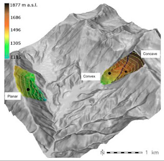
Geomorphological control on variably saturated hillslope hydrology and slope instability

This paper, which has a long history, treats the influence of geomorphology on stability. Not a new topic indeed, but usually saying that convergent topographies favour landslids was a matter of qualitative arguments.  Here it is made by using DEM analysis, a 3D Richards equation solver, and a sound model for hillslope stability. That's the difference for who can appreciate it.
Please, find the preprint, clicking on the Figure. I think the reading is enjoyable and I hope the Journal will accept it soon. 

Sunday, March 8, 2015

The width function

The width function is said to have been introduced in 1976 by Mike Kirkby (one of his many achievements). If you consider the map of the distances from any point in a basin to the outlet, following the drainage direction, you get the map of distances to outlet, a map easy to obtain from DEMs, as below:
The width function is actually the distribution of the above distances, which can be normalized by the total area to obtain a probability distribution function (of distances from the outlets along the drainage path).  Below, please find the width function of the above basin.

The width function has a quite irregular form, and it has been suggested by Marani, S. et al, 1991 that he can be seen as the product of a multiplicative dissection of the area and having, in particular conditions, the structure of a multifractal (as in the case of the Peano curve) - see also Marani, M. et al., 1994.  Anyway, looking at its parts you have a picture like this ones below. In the first, "strips" of five kilometers are considered:
In the second, strips of 2.5 kilometers are considered:
Wow, in the third, strips of one kilometer are eventually considered:

What happens here is that point at the same (kilometric) distance to outlet do not actually constitute continuous strips, and are, in some cases far apart. This is clearly a manifestation of how the river network structure is non trivial. Figures are by Giuseppe Formetta. The basin is the Little Washita in Oklahoma. Reproducing the same pictures is easy with STAGE. 

References

Kirkby MJ, 1976. Tests of the random network model, and its application to basin hydrology. Earth Surface Processes 1(3): 197–212. ISSN 1931-8065. doi:10.1002/esp.3290010302.

Marani, A., R. Rigon and A. Rinaldo, A Note on fractal channel networks,Water Resources Research, (27)5, 3041-3049, 1991.

Marani, M., A. Rinaldo, R. Rigon and I. Rodriguez-Iturbe, Geomorphological width function and the random cascade, Geophysical Research Letters, 21(19), 2123-2126, 1994.  


Sunday, October 13, 2013

A paper on the Horton Machine

The Horton Machine toolset has gained a certain stability during the years, and I currently use it in my Hydrology class. There is a tutorial in Italian and an out-of-date Reference Manual which are waiting for being merged into a unique English Manual. Meanwhile, here it is a paper that explains it, as much as it can be made in a paper. This would be part, after having passed the appropriate peer review, of an open access book of the British Society for Geomorphology, Clarke (2013), section 2.4

The book chapter draft can be found here. The complimentary material to reproduce the manuscript figures can be found in this post.

Reference

Clarke, L.E. (Ed.) Geomorphological Techniques (Online Edition). British Society for Geomorphology, London. ISSN: 2047-0371,

Thursday, September 27, 2012

My Past Research on Hydro-geomorphology


The work on evolution of river networks, certainly enters also in this category. Here however, it is reported about those papers that deals directly with quantitative geomorphological analysis.
In most of the papers, the relationships between the various parts of a river basin are analyzed with fractal geometry techniques.  Such knowledge is useful not only for the evaluation of river basin evolution models, but also in  identifying the nature of their hydrological response to given events and their paleoclimate.  In [J2], using the Peano Basin, a mathematical reference structure, it is suggested that the amplitude function of natural networks can be reproduced with a multifractal multiplicative
process.   In [J11] this concept was rigorously formalized in the framework of random multifractal cascades theory.


The fractal properties, that is  power laws relating to  contributing areas and the length of stream reaches, were rigorously analyzed in [J15]. In [J17] more relationships between these characteristic quantities were found and an explanation of the nature of Hack's law is suggested.
In [J27] the structure of the river networks is further investigated by analysing the tributaries statistics. The relationships were verified experimentally by means of Digital Elevation Models (DEM).

Given programs for the extraction of digital terrain models (DEM) and their treatment, the natural development was the implementation of an open-source geographic information system: JGrass [s2].  JGrass, now part of uDig, contains within the package a large amount of GIS methods, jointly known as the Horton Machine [eb-3] to support the most common and some less common tools of analysis for river networks topology,  channel extraction, hillslope delineation. A review of these tools is in [a57].

Papers and work on landslide triggering are also concerned with geomorphology but referred in a different post.

References

[j2] - Marani, A., R. Rigon and A. Rinaldo, A Note on fractal channel networks,Water Resources Research, (27)5, 3041-3049, 1991.

[j11] - Marani, M., A. Rinaldo, R. Rigon and I. Rodriguez-Iturbe, Geomorphological width function and the random cascade, Geophysical Research Letters, 21(19), 2123-2126, 1994.

[j15] - Maritan, A., A. Rinaldo, R. Rigon, I. Rodriguez-iturbe and A. Giacometti, Scaling laws for river networks, Physical Review E , 53, 1510, 1996.

[j17] - Rigon, R., I. Rodriguez-Iturbe, A. Rinaldo, A. Maritan, A. Giacometti and D. Tarboton, On Hack’s law, Water Resources Research, 32(11), 3367, 1996

[s2] Jgrass (since 2002): it is a full featured GIS system built to support the hydro- geomorphological research of the group since the early 2000s. Recently it has been integrated in uDig. Current developments (which go far beyond my contribution) are available at: http://udig.refractions.net/

[eb3] - R.Rigon, E. Ghesla, C. Tiso and A. Cozzini, The Horton Machine, pg. viii, 136, ISBN 10:88-8443-147-6, University of Trento, 2006

[j27] - Convertino, M, Rigon, R; Maritan, A; I. Rodriguez-Iturbe and Rinaldo, A, Probabilistic structure of the distance between tributaries of given size in river networks, Water Resour. Res., Vol. 43, No. 11, W11418, doi:10.1029/2007WR006176, 2007

[a57]- W. Abera, A. Antonello, S. Franceschi, G. Formetta, R Rigon , "The uDig Spatial Toolbox for hydro-geomorphic analysis" in Geomorphological Techniques, v. 4, n. 1 (2014), p. 1-19

Wednesday, March 2, 2011

Channel Initiation

The contribution of few days ago Where do channels begin ? looks to channels' forming processes. The scientific debate has another side which regards channels network extraction.

A recent paper by Orlandini et al. (2011), whose results where also presented at CATHY meeting last January, presents a concise but nice introduction to the topic, and a few results based on works made in the Dolomites. A parallel introduction can be found in my slides.

Certainly Orlandini and Moretti have the merit to have produced the most cleaned methods to produce channels delineation (all papers cited below), and in parallel, proper methods for estimating the upslope contributing areas of any point in a catchment. This is an essential ingredient of the whole story of proper watershed (and drainage directions) delineation and we implemented most of their work (not all of it unfortunately) in JGrass. The rest is kind of an epiphenomenon.


Reference

Orlandini, S., and G. Moretti (2009a), Determination of surface flow paths from gridded elevation data, Water Resour. Res., 45, W03417, doi:10.1029/2008WR007099.

Orlandini, S., and G. Moretti (2009b), Comment on ‘‘Global search algo- rithm for nondispersive flow path extraction’’ by Kyungrock Paik, J. Geophys. Res., 114, F04004, doi:10.1029/2008JF001193.

Orlandini, S., Tarolli, P., Moretti, G., Dalla Fontana, G. (2011). On the prediction of channel heads in a complex alpine terrain using gridded elevation data, Water Resources Research, 47, W02538, doi:10.1029/2010WR009648

Thursday, February 24, 2011

Where do channels begin ?

It is the title of a famous paper by David Montgomery and Bill Dietrich about channel initiation which appeared in Nature, in 1988, and was followed by a subsequent paper (in 1994 on Water Resources Research): and BTW by many others in the following years to confirm, and using their findings.

So we know much more than then about. However, those pioneering contribution, did refer to what happens in sloped but hilly environments, of Oregon and California. What about the Alps ?

Recent work by Paolo Tarolli brought some quantitative light on the issue. He presented his work at last January Cathy meeting that can be summarized as follows:

-the availability of very detailed laser scanner of topography allows a great opportunity to use objective methods to single out channels' head.
- in a region of the Italian Alps (Dolomites) were surveyed at least two main processes that drive channel initiation: i) channel heads formed essentially by surface runoff (mass wasting, in form of debris flows or "more traditional" erosion), ii) and areas where geology and groundwater seeping upward exercise important controls on channel initiation.
- Wavelet analysis allows to smooth the topography the right way to use in sequence "curvatures" for channels head initiation.


I hope it will not pass to much time before we can bring these tools inside our jgrasstools.

For who is interested, relevant papers are listed below:

References

David R. Montgomery & William E. Dietrich,Where do channels begin? , Nature 336, 232 - 234 (17 November 1988); doi:10.1038/336232a0

MONTGOMERY and DIETRICH. Source Areas, Drainage Density, and Channel Initiation . Water Resour. Res. (1989) vol. 25 (8) pp. 1907-1918

Orlandini, S., Tarolli, P., Moretti, G., Dalla Fontana, G. (2011). On the prediction of channel heads in a complex alpine terrain using gridded elevation data, Water Resources Research, 47, W02538, doi:10.1029/2010WR009648

Passalacqua, P., Tarolli, P., Foufoula-Georgiou, E. (2010). Testing space-scale methodologies for automatic geomorphic feature extraction from LiDAR in a complex mountainous landscape, Water Resources Research, 46, W11535, ISSN: 0043-1397, doi:10.1029/2009WR008812.

Pirotti and Tarolli. Suitability of LiDAR point density and derived landform curvature maps for channel network extraction. Hydrol. Process. (2010) vol. 24 (9) pp. 1187-1197

Sofia, G., Tarolli, P., Cazorzi, F., Dalla Fontana, G. (under review). Channel heads and channel network identification from high-Resolution DTM: a statistical approach, Hydrol. Earth Syst. Sci., ISSN: 1027-5606.

Tarolli, P., Dalla Fontana, G. (2009). Hillslope-to-valley transition morphology: new opportunities from high resolution DTMs, Geomorphology, 113, 47-56, doi:10.1016/j.geomorph.2009.02.006