Showing posts with label landslides. Show all posts

Monday, April 10, 2017

Open-source software for simulating hillslope hydrology and stability

This is the material of the SC34/NH10.2 ECS: Open-source software for simulating hillslope hydrology and stability
by Giuseppe Formetta, Francesco Serafin, Riccardo Rigon, Raffaele Albano and Luigi Lombardo (co-conveners)

session of the  2017 EGU meeting in Wien.
For all of this work it is necessary to download a number of softwares.

Monday, October 17, 2016

Hillslope stability tools

Here I am on landslides. I gave some contributions to this topics, and I wrote also something about, however I never tried to put a list of models that can be used.

As a general reading I would suggest certainly 


It is one of the few books that have a modern approach to quantitative hillslope hydrology. Who starts from it, is already a few years behind others.  Fortunately, Ning Lu covered some of the book chapters in the summer school on landslides held in 2013, and you can also learn directly from his voice and video.

If you have red the book, you can then understand that having at least a 2D tool for assessing hillslope stability is a necessity that you cannot avoid. 

So here they are my favorite tools:

Jgrasstools (see also here) - They contain a SHALSTAB implementation that can be used for comparison. They also contains the necessary tools for terrain analysis. 
CISLAM -  model was originally implemented in R by Cristiano Lanni (GS), but it was ported to JGrasstools in a Google Summer of Code by Marco Foi. I cannot guarantee its quality, since I never used it, but it is built on the theory I co-developed with Cristiano that you can find addressed here. (Jgrasstools are migrated to the gvSIG 2.3 now or are available trough S.T.A.G.E.).

Boussinesq - This is not directly a tool for hillslope stability estimation. However, it serves to estimate the water content (neglecting at the moment, the vadose zone). There are two version of it:  a C version by Emanuele Cordano (stable and working) and a Java version by Francesco Serafin (that is in Java, for being inserted into OMS3, and still a project under construction).

RiDI. - This was developed by Fabio Ciervo in his Ph.D.  it has the peculiarity that it implements a double porosity soil water retention curve proposed by Nunzio Romano (GS) and coworkers.

GEOtop - It was used a lot to this scope, conjointly with simple and less simple hillslope stability analysis (we did some papers with it).

At present, all the tools require to become part of a consistent framework. But we (Giuseppe Formetta -GS-, Francesco Serafin and I) are working on it, looking forward to the next EGU General Assembly in Wien (April 2017). Stay tuned. 


Tuesday, November 24, 2015

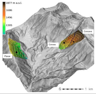
Geomorphological control on variably saturated hillslope hydrology and slope instability

This paper, which has a long history, treats the influence of geomorphology on stability. Not a new topic indeed, but usually saying that convergent topographies favour landslids was a matter of qualitative arguments.  Here it is made by using DEM analysis, a 3D Richards equation solver, and a sound model for hillslope stability. That's the difference for who can appreciate it.
Please, find the preprint, clicking on the Figure. I think the reading is enjoyable and I hope the Journal will accept it soon. 

Monday, May 18, 2015

Bimodal pore size distribution and hillslope stability

This post is to highlight the work of Fabio Ciervo, a Ph.D. student of Mariolina Papa that I co-advised with Vincente Medina. His thesis had the merit to put together two nice aspects of the recent research on soils. The first came from the work of Nunzio Romano [1] and co-workers, who show consistently that many soils present a bi-modal distribution in porosity, with effects in the form of the soil-water-retention curves (SWRC), and hydraulic conductivity, once Burdine or Mualem's [2] theory is applied. The other is the novel theory of hillslope stability coming out from the joint work of Lu, Likos, and Godt (e.g. [3]).

Who wants to enjoy his thesis can find it here: Fabio Ciervo, Modeling hydrologic response of structured soil, University of Salerno, 2015.
The code, developed in Java, that solves Richards 1D equation using these bimodal SWRC can instead be found on Github.
The Thesis produced a first paper which is under review in Vadose Zone Hydrology Journal.

Some References (others in the Dissertation)

[1] -Romano, N., Nasta, P., Severino, P., and Hopmans, J.W., Using bimodal lognormal function to descrivbe soil hydraulic properties, Soil. Sci. Soc. Am. J.,  75(2), 468-480, 2011

[2] - Roth, K., Soil PhysicsInstitute of Environmental Physics, Heidelberg University,
D-69120 Heidelberg, Germany, 2012

[2] - Lu, N., and Godt, J., Hillslope hydrology and stability, Cambridge University Press, 2013

Thursday, November 27, 2014

Ning Lu lectures on hillslope processes and (especially) stability, at the Summer School on Landslides

In 2013 University of Calabria organised a very interesting School on Landslide triggering (many thanks to Lino Versace, Giovanna Capparelli and Giuseppe Formetta).  I actually gave a hand to organised it, and  I also gave a lecture on Richards equation.  Waiting for the official post of the lectures at the school site (after which, I will remove my videos), I cannot wait anymore to have on-line the lectures by Ning Lu. He gave four talks taken out of his beautiful book, Hillslope Hydrology and Stability, written with Jonathan Godt, new coordinator of the USGS landslide hazards program, and former co-advisor of my Ph.D. student Silvia Simoni (her thesis here).  A must-watch for any guy in the field !

First talk: A brief conceptual history of soil hydrology and soil mechanics (from Chapter 6 of his book)


Third talk, part II: Hydro-mechanical properties of hillslopes (Chapter 8 of the book)


Fourth talk, part I: Failure surfaces  (Chapter 9 the book)


Fourth talk, part II: Field based stability analysis (Chapter 10 of his book)


Wednesday, October 8, 2014

CISLAM

CISLAM is the simplified hydrological model produced by Cristiano Lanni during his P.h. D which was devoted to the study of landslide triggering. The theory behind the code is commented in a Hydrological Processes Paper, and the original code was written in R, but Marco Foi ported it to the Jgrasstools during a fortunate Google Summer of Code.

  • The CISLAM Manual can be found here
  • Source code can be found here.


You can find a jar file ready to be used within a hacked version of JGrassTools 0.7.7: in fact, Marco had to modify a little JGrasstools to get it working. These changes were, so far, never introduced in version 0.8, and therefore for using CISLAM, it is necessary to use this version of JGrasstools: 


The tool has been tested to on the data set that can be found here, the same described in the manual. Other tests, would be necessary indeed. 

Thursday, September 4, 2014

Atlas of Mortality and Economic Losses from Weather, Climate, and Water Extremes (1970-2012)

With the limits that these large scale project have, which is neglecting most of the micro-phenomena, as small landslides, that causes huge economical losses, and several life losses, this is, however, a reference to keep in mind when talking about climate related hazards.

It was produced by WMO and it is available here. As it reports in introduction:
"Weather, climate and water-related disasters are on the rise worldwide, causing loss of life and setting back economic and social development by years, if not decades. From 1970 to 2012, 8 835 disasters, 1.94 million deaths, and US$ 2.4 trillion of economic losses were reported globally as a result of hazards such as droughts, extreme temperatures, floods, tropical cyclones and related health epidemics, according to a new report."

Monday, April 7, 2014

Richards equation (and hillslope hydrology) video from the Summer School on Landslides

Last summer school on landslides that University of Calabria Organised was pretty successful.  Besides organising it together with Giovanna Capparelli and Giuseppe Formetta, I also gave a lecture on Richards equation (you can find the slides here). Finally, thanks to the organisation, the videos of my lecture are available.

The first part


The second part

The third part

Tuesday, September 24, 2013

Clarifications about a formula

I reading the TRIGRS manual I fond this:

Comparison of Computed Results with Published Analyses

We tested TRIGRS against Iverson’s (2000) examples from the Minor Creek landslide and from an experiment at the USGS debris-flow flume and were able to reproduce his results for pore pressure and factor of safety profiles. Thus, we were able to verify that the computer code accurately implements Iverson’s (2000) formulas for pore pressure and factor of safety. After publishing the original version of TRIGRS, students of Ricardo Rigon (University of Trento, Trento, Italy) pointed out an error in the coordinate transformation in Iverson’s (2000) original paper. Correction of that simple error causes our numerical results to differ somewhat from Iverson’s (2000) published values, though preserving their basic form. Folders named

25“MinorCreek” and “flume” contain files with necessary data to reproduce these results. By varying elapsed time, t , in the initialization file, the user can compute pressure head and factor of safety profiles like those of figures 7, 8, 10, and 11 of Iverson (2000). Note that the computed profiles conform to the limit imposed by equation 3. We have also verified that the new version of TRIGRS described in this report reproduces the published results of Srivastava and Yeh (1991). Data in the folder “sy91” produce profiles that allow the user to reproduce the curves plotted in figure 3 of Srivastava and Yeh (1991).


A part the misspelling of my name (two "r"s, not one like in Spanish), I need to precise that the error was discovered by Emanuele Cordano, a.k.a. the authors of at least  couple of papers with me, and some R packages useful for hydrologists.  His papers, maybe difficult to read, and so far not kissed by the goddess of citations,  remain among my own favorite. 

References

[ J28] - Cordano E. R. Rigon, A perturbative view on the subsurface water pressure response at hillslope scale, Water Resour. Res., Vol. 44, No. 5, W05407- W05407, doi:10.1029/2006WR005740, 2008


Boussinesq code is available on Github.

R- Software

RMWAGEN, a weather generator, a package that contains functions for spatial multi-site stochastic generation of daily timeseries of temperature and precipitation. A presentation can be found here.

Soilwater, A package for plotting soil water retention curves and hydraulic conductivity written by Emanuele Cordano, Fabio Zottele and Daniele Andreis.

Wednesday, May 22, 2013

A summer school on landslides modelling (July 4-10 2013)


Shallow landslides are a widespread hazard on which I did a few selected publications. Modelling landslide occurence is problem that is difficult to grasp also because knowledge about the phenomenon covers geology, geotechnics-geo-mechanics , agronomy (especially regarding the role of roots) and, obviously, hydrology. As a result a modern landslide expert has to get accustomed with several point of views which are often divergent, and various modelling approaches and numerics, which makes uneasy a synthesis. Historically the field has crystallised along some concepts and methods which are summarised in one of my previous posts (Guidelines for the mapping of the triggering of landslides and debris flow). To investigate new ideas, mix the competences, and summarise good old tools, University of Calabria and CUDAM (of University of Trento) organised a summer school of which you can find information in the link below the picture.

Lectures of the school were:

Dino Bellugi, Matteo Berti, Giambattista Chirico, Ning Lu, Riccardo Rigon, Cristina Rulli.

The twenty participants came from nine nations and were selected from doctoral students and post-docs.
In the summer school website, it is here, you can find the lectures and the videos of the school.

Friday, February 1, 2013

Paraglacial geomorphology

We often talk about landscape evolution (and I have a little history on the subject). However, we usually forget that from 65Ky and 12Ky of years ago a lot of our Earth was covered by a glaciation. The image below, robbed from a Mr. Kurt Werth presentation at "At North of Trento and South of Bolzano"(1,2,3) Meeting, illustrates the situation in the place where I live, the river Adige basin.
I do not know which is the precision of the map, but it illustrates clearly which was the geneal situation. Cause of this,  many of the geomorphic features we see nowadays where created by the glacier retreat and by subsequent land-sculpting. Alluvial fans (some hundreds of them) were formed later. Big rock avalanches (according also to isotopic measurements) crumbled down among 10Ky and 3Ky ago.
Therefore it is time that  alpine geomorphology (and modelling) put Paraglacial situations inside its horizon. Actual landslides and sediment production is strongly affected by what the glaciers left.

Reference
Ballantyne, C.K. - Paraglacial geomorphology, Quaternary Science Reviews 21 (2002) 1935–2017


Monday, October 1, 2012

Guidelines for the Mapping of the Triggering of Landslides and Debris Flow


My studies on shallow landslides were not purely theoretical but directed to make safer the mountain environment in which I live. Therefore, since the beginning of my activities there was an effort to convert theoretical results into practical tools, which, in turn, helped research. These guidelines written for the Danube Flood Risk Project come with this attitude. The work was also supported by the IRASMOS EU Project and, more recently, from the Trento Province. While reading the guidelines themselves is probably the simplest way to approach the mapping of landslide triggering according to my perspective, I also make public the presentation that I gave last and this year on the subject.

The first presentation is an introduction to the subject of hydrological hazards in mountains areas and the topic of guidelines:


The second contains and comments some applications of the guidelines on catchments in Trentino.


All the operation seen (except for the very recent CI-SLAM model) can be reproduced using the tools in the Spatial Toolbox of uDig or using GEOtop.


References

Beven, K J and Kirkby, M J. 1979, A physically based variable contributing area model of basin hydrology Hydrol. Sci. Bull., 24(1),43-69

Beven, K, Rainfall-runoff modelling: the primer, Wiley, 2001

Borga, M., G. Dalla Fontana, F. Cazorzi, Analysis of topographic and climatic control on rainfall-triggered shallow landsliding using a quasi-dynamic wetness index, Jour. Hydrol., 268, 56-71, 2002
D’Odorico, P. and R. Rigon, Hillslope and channels contribution to the hydrologic response, Water Resour Res, 39(5) , 1-9, 2003

Lanni, C.; McDonnell, J. J.; Rigon, R., On the relative role of upslope and downslope topography for describing water flow path and storage dynamics: a theoretical analysis, Hydrological Processes Volume: 25 Issue: 25 Pages: 3909-3923, DEC 15 2011, DOI: 10.1002/hyp.8263

Lanni C., J. McDonnell JJ, Hopp L., Rigon R., "Simulated effect of soil depth and bedrock topography on near-surface hydrologic response and slope stability" in EARTH SURFACE PROCESSES AND LANDFORMS, v. 2012, (In press). - URL: http://onlinelibrary.wiley.com/doi/10.1002/esp.3267/abstract . - DOI: 10.1002/esp.3267

Lanni C., Borga M., Rigon R., and Tarolli P., Modelling catchment-scale shallow landslide occurrence by means of a subsurface flow path connectivity index, Hydrol. Earth Syst. Sci. Discuss., 9, 4101-4134, www.hydrol-earth-syst-sci- discuss.net/9/4101/2012/ doi:10.5194/hessd-9-4101-2012, (in press at HESS)

Other papers and material about landslides can be found in this blog following the "Landslides" label.

Friday, September 28, 2012

My Past Research on Shallow Landslide and Mass Flow Triggering


The role of hydrology in triggering mass movements was initially confronted with an implementation of the theories of Montgomery and Dietrich [1994] (MD), and the case of instability caused by surface runoff [A21, A26, A27].  The study then continued with the analysis of transient phenomena, that is the instabilities caused by the propagation of pressure waves in the unsaturated medium  [A31, A32], according to the theory by Iverson [2000] (I), and integrating  the two, MD1994 and I2000, views even in the case of rainfall of varying intensity [A21, J23].
Then, the simplified approach  (important in as so much as it highlighted some qualitative aspects of infiltration in the hillslopes) was supplanted by the use of the GEOtop model for the continual simulation of hydrological variables [A38, J26], and transient effects, within a minimal set of simplifications.  The use of GEOtop has allowed for the separation of the hydrological part, effectively modeled by GEOtop, and the geotechnical part, contained in the GEOtop-FS model [J26].  Particularly, the latter of these was the subject of a probabilistic treatment that introduced uncertainties into the main geotechnical parameters  [J26].
The paper [J26], and the thesis of Silvia Simoni introduced a systematic approach to the identification of areas of instability that made full use of the potential of on-site geophysical measurement campaigns and the a priori characterization of geotechnical properties of the soil in the laboratory, without using back analyses for the calibration of parameters as is generally done by simplified models.  The IRASMOS Reports [rep06, rep07 and rep08] represent a summary of the literature available on this subject which has been eventually refined in [rep09].


The most recent work  has been focused on trying to understand the dynamics of subsurface flow  in  by means of virtual experiments [A43] with GEOtop, and in more conceptualized terms to explicit the role of the variability of depth of soil [J33, J35, thesis of Cristiano Lanni]  with the model denominated CI-SLAM.  The result is the introduction of the concept of "hydrological connectivity" of the hillslopes, which is realized when a perched water table forms that covers the whole basin.  The connectivity concept bridged the gap between hillslope hydrology and basin hydrology, and has also consequences important for hillslopes' stability [J37]. In fact these concepts allows a better statistical identification of landslide areas, than previous similar models.  [J35] also contains a preliminary attempt to use the theories of self-organizing criticality in the context of instability propagation, which, evidently, heralds the actual landslide itself.

Paper [J46] faces the issues related to the choice of a certain parameterisation of the soil retention curves and analyses their relation to hillslope stability. It uses a new theory that uses double porosity, and estimates the stability with the use of the new theories by Lu, Likos and Godt.

References

In English:

[ J23] - D’Odorico, P., Fagherazzi G., Rigon R. Potential for landsliding: Dependenceon hyetograph characteristics J. Geophys. Res., Vol. 110, No. F1, F01007 10.1029/2004JF000127 10 February 2005

[J26] Simoni, S., F. Zanotti, G. Bertoldi and R. Rigon, Modelling the probability ofoccurrence of shallow landslides and channelized debris flows using GEOtop-FS, Hydrol. Process. 22, 532–545, 2008, DOI: 10.1002/hyp.6886

[J33] - Lanni, C.; McDonnell, J. J.; Rigon, R., On the relative role of upslope anddownslope topography for describing water flow path and storage dynamics:a theoretical analysis, Hydrological Processes Volume: 25 Issue: 25 Pages: 3909-3923, DEC 15 2011, DOI: 10.1002/hyp.8263

[J35] - Lanni C., J. McDonnell JJ, Hopp L., Rigon R., "Simulated effect of soil depthand bedrock topography on near-surface hydrologic response and slope stability" in EARTH SURFACE PROCESSES AND LANDFORMS, v. 2012, (In press). - URL: http://onlinelibrary.wiley.com/doi/10.1002/esp.3267/abstract . - DOI: 10.1002/esp.3267

[J37] Lanni C., Borga M., Rigon R., and Tarolli P., Modelling catchment-scale shallowlandslide occurrence by means of a subsurface flow path connectivity index, Hydrol. Earth Syst. Sci. Discuss., 9, 4101-4134, (in press at HESS)

[A31] - E. Cordano, P., Bartolini, Rigon R. A flexible numerical approach to solving a generalized Richards’ equation problem and some applications, 2004

[rep06]- Rigon R., Rickenmann D., Catalogue of causes and triggering thresholds (Ed), IRASMOS EU Project Deliverable 1.1, 2007

[rep07] - Rigon R. (Ed), State-of-the-art models: their transferability and model application, IRASMOS EU ProjectDeliverable 1.2, 2007

[rep08] - R. Rigon, State of the art of prediction techniques, IRASMOS EU Project Deliverable 1.3, 2007

[rep09] - R.Rigon, Franceschi, S., Monacelli, G., and Formetta, G., The triggering of landslides and debris flows and their mapping, Danube Flood Risk EU Project, 2012

[J46] - Ciervo F. ,  Casini F. , Papa M.N. ,  Rigon R., Some remarks on bimodality effects of the hydraulic properties on shear strength of unsaturated soils, Vadose Zone Hydrology, published electronically, doi:10.2136/vzj2014.10.0152, 2015

In Italian:

[A21] - D’Odorico, P., Fagherazzi S., Rigon R. Frane superficiali e idrologia deiversanti: Un possibile metodo di indagine. Atti del XXVIII Convegno di Idraulica e Costruzioni Idrauliche, vol. V, pp.177-184, 2002

[A26] - Tiso, C., Bertoldi G. and R. Rigon. Il modello Geotop-SF per la determinazione dell’nnesco di fenomeni di franamento e di colata. Atti del Convegno Iterpraevent 2004, Riva del Garda, 24-28 Maggio 2004

[A27] - Rigon, R., A. Cozzini, S. Pisoni, G. Bertoldi e A. Armanini. A new simple method for the determination of the triggering of debris flows. Atti del Convegno Interpraevent 2004, Riva del Garda, 24-28 Maggio 2004

[A32] - Cordano, E., Panciera R., Rigon R., Bartolini P. Sulla soluzione diffusiva dell’equazione di Richards. Atti del XXIX Convegno di Idraulica e Costruzioni Idrauliche, Settembre 2004

[A43] Lanni C., Cordano E., Rigon R., Tarantino A., Analysis of the effect of normaland lateral subsurface water flow on the triggering of shallow landslides witha distributed hydrological model. in from geomorphology mapping to dynamic modelling, Strasbourg: CERG, 2009. Atti di: A Tribute to Prof. Dr. Theo van ASCH, Strasbourg, 6th-7th February 2009

Wednesday, September 19, 2012

Soil Depth Estimation

Estimation of soil depth is crucial for the assessment of hillslope hydrological processes (e.g.
Tromp van Meerveld and McDonnell, 2006) and landslide stability (e.g Lanni et al., 2011, 2012).  Is a topic that had a lot of attention in the community of geomorphologists but indeed it remain still an open. In a recent paper (e.g. Lanni et al., 2012, under the final stage of review in HESS) we wrote a very short review:

"The spatial distribution of soil depth is controlled by complex interactions of many factors (topography, parent material, climate, biological, chemical and physical processes) (e.g., Summerfield, 1997, Pelletier and Rasmussen, 2009, Nicotina et al., 2011). As a result, soil depth is highly variable spatially and its prediction at a point is difficult. Moreover, soil depth survey is time consuming and soil depth is difficult to measure even for small basins (Dietrich et al., 1995). Various methods have been explored to allow the estimation of soil depth over landscapes. A process-based approach was suggested by Dietrich et al. (1995) for predicting the spatial distribution of colluvial soil depth. Based on this approach, topographic curvature may be considered a surrogate for soil production. Heimsath et al. (1997, 1999) validated the relationship between curvature and soil production based on observations of cosmogenic concentrations from bedrock in their Tennessee Valley site in California. This approach was incorporated into a landscape evolution model by Saco et al. (2006) to evaluate the dependence of soil production on simulated soil moisture. Roering et al. (1999) supported the idea that soil production follows a non linear equation and, therefore, modified the dependence of soil depth relationships. However, the various modeling approaches for predicting soil depth over landscapes, described above, showed only partial success (Tesfa et al., 2009).
In contrast to the process-based approaches, a number of studies have applied statistical methods to identify relationships between soil depth and landscape topographic variables (e.g., slope, wetness index, plan curvature, distance from hilltop, or total contributing area) (e.g. Gessler et al., 1993, Tesfa et al., 2009, Catani et al., 2010). Some of these works reported good predictive capabilities for these statistical relationships. For instance, Tesfa et al. (2009) report that their statistical models were able to explain about 50% of the measured soil depth variability in an out-of-sample test. This is an important result, given the complex local variation of soil depth."

Our short review possibly miss some interesting reference as the one by D'Odorico (2000) on a possible bi-stable evolution equation, and our little work in Bertoldi et al. (2006) that generalize Heimsath's to include random variaility in depth. 

However, reduction of soil depth formation simply to a geometrical factor (as implied by using equations with homogenous parameters) is clearly not enough. Pedologists know it. But so far I found only a few able to enter in the strict path of learning our equations. 

Anyway,  looking for R based hydrological resources I found this explanatory map by Roudier and Beaudette:

Looking at it gives clearly the idea that soil depth does not depend (only) on geometry. Where slope and curvature remain constant, anyway soil depth varies.

It is easy to think that it depend on variability in the geologic substrate,  soil cover (grass, plants), and soil use (for instance grazing or the presence of animals). But there is any pedologist out there which could help us to built a consistent quantitative theory ?

As usual, the references could be a starting point for a more in-depth literature search.

References

Catani, F., Segoni, S., and Falorni, G.: An empirical geomorphology-based approach to the spatial prediction of soil thickness at catchment scale, Water Resour. Res., 46, W05508, doi:10.1029/2008WR007450, 2010. 

Dietrich, W. E., Reiss, R., Hsu, M.-L., and Montgomery, D. R.: A process-based model for colluvial soil depth and shallow landsliding using digital elevation data, Hydrol. Processes, 9, 383 – 400, doi:10.1002/hyp.3360090311, 1995.

D'Odorico, P. (2000), A possible bistable evolution of soil thickness, J. Geophys. Res., 105(B11), 25,927–25,935, doi:10.1029/2000JB900253.

Gessler, P. E., Moore, I. D., McKenzie, N. J., and Ryan, P. J.: Soil landscape modeling and spatial prediction of soil attributes, Int. J. Geogr. Inf. Syst., 9, 421– 432, doi:10.1080/02693799508902047, 1995.

Heimsath, A. M., Dietrich, W. E., Nishiizumi, K., Finkel, R. C.: The soil production function and landscape equilibrium, Nature, 388, 358– 361, doi:10.1038/41056, 1997.

Heimsath, A. M., Dietrich, W. E., Nishiizumi, K., Finkel, R. C.: Cosmogenic nuclides, topography, and the spatial variation of soil depth, Geomorphology, 27, 151– 172, doi:10.1016/S0169-555X(98)00095-6, 1999.


Lanni, C., McDonnell, J., Hopp, L. and Rigon, R.: Simulated effect of soil depth and bedrock topography on near-surface hydrologic response and slope stability, Earth Surf. Process. Landforms, 2012, doi: 10.1002/esp.3267.

Lanni, C., Borga M., Tarolli P., Rigon R., Modelling shallow landslide susceptibility by means of a subsurface flow path connectivity index and estimates of soil depth spatial distribution , HESSD, 2012
Nicotina, L., Tarboton, D. G., Tesfa, T. K., Rinaldo, A.: Hydrologic controls on equilibrium soil depths, Water Resour. Res., 47, W04517, doi:10.1029/2010WR009538, 2011.

Liu, J., Chen, X., Lin, H., Liu, H., & Song, H. (2013). A simple geomorphic-based analytical model for predicting the spatial distribution of soil thickness in headwater hillslopes and catchments. Water Resources Research, n/a–n/a. doi:10.1002/2013WR013834

Pelletier, J. D. and Rasmussen, C.: Geomorphically based predictive mapping of soil thickness in upland watersheds, Water Resour. Res., 45, W09417, doi:10.1029/2008WR007319, 2009.

Roering, J.E., Kirchner, J.W., and Dietrich, W.E.: Evidence for nonlinear, diffusive sediment transport on hillslopes and implications for landscape morphology, Water Resorces Research, vol. 35(3), 853–870, 1999.

Saco, P. M., Willgoose, G. R., and Hancock, G. R.: Spatial organization of soil depths using a landform evolution model, J. Geophys. Res., 111, F02016, doi:10.1029/2005JF000351, 2006.

Summerfield, M. A.: Global Geomorphology, 537 pp. Longman, New York, 1997

Tesfa, T. K., Tarboton, D. G., Chandler. D. G., and McNamara, J. P.: Modeling soil depth from topographic and land cover attributes, Water Resour. Res., 45, W10438, doi:10.1029/2008WR007474, 2009.

Tromp-van Meerveld, H.J., and McDonnell, J.J.: Threshold relations in subsurface stormflow: 2. The fill and spill hypothesis, Water Resources Research, 42, W02411. 2006.

Monday, April 16, 2012

Hydro-geological hazard in Italy as Mapped by the local authorities

A friend gave pointed out to me this morning this map of hydrogeological hazards in Italy, as produced by the local authorities and collected by the Italian Ministry of Italy.  The full map at higher resolution (1.4 Mb) can be retrieved here (I think it is public and can be found somewhere in the Environmental Ministry of Italy). "Carta delle aree ad alta criticita' idrogeologica" means: maps of the area with the highest potential hazards. Red are landslides, blue are flooding, green snow avalanches hazards.


Well, some parts of Italy (as my Province of Trento) are very red and full of hazard. Some others (same hydrological and geological conditions, as the Province of Bolzano and Province of Belluno) are white: almost no hazard at all. (I tend to support the idea, since I was involved in part of its construction, that the hazard map of Trentino was produced with state of art techniques. But I also know that officiers of the other Provinces are also rigorous people. Then ?). The case of Emilia Romagna is also perfect example of this partition.  The Apennines in Emilia (under the Authority of River Po ?) are really red.  The Apennines in Romagna (under the river Authority of Reno River ?) are almost white.
Why these differences ? Different techniques of mapping ? Different "political choices" ?  Different stage of production of the maps (did all really made it) ?

Who knows can give me a clue ?

Wednesday, March 28, 2012

Modelling catchment-scale shallow landslide occurrence by means of a subsurface flow path connectivity index

This paper extends the concept already introduced in  two previous papers on Hydrological Processes  and Earth Surface Processes and landforms. The idea pursued in the first was that hillslope processes can be conceptualized in order to obtain a topographic index useful for a simple hydrological modelisation of hillslopes. The second paper investigates the role of soil depth and push further the conceptualization, besides introducing some concept of self-organization in the production of instabilities. 

This third paper in row applies the theory above to a case in North of Italy, and tries finally to fill the gap between hillslope modeling and catchment analysis. The paper also introduces the concept of catchment connectivity, which is usually given for granted but it is, indeed, not always present, and build on previou work by Jeff McDonnell and collaborators and Stuart Lane.  Finally the paper investigates the hillslope stability of the basins above.

The model described, CISLAM is available as an OMS component here

Monday, January 16, 2012

Simulated effect of soil depth and bedrock topography on near-surface hydrologic response and shallow landslide triggering by Lanni, McDonnell, Hopp and Rigon


We have just submitted a paper  that, looked from a certain perspective, can be thought on the evolution of soil moisture content in presence of variable soil depth. In fact, variable soil depth, jointly with the fact that increases in hydraulic conductivity follows the increase in water pressure, and that hydraulic conductivity itself can often be considered negligible when the soil is unsaturated, delays the formation of a widespread water table in a hillslope. Therefore the effective contributing area above a point of a catchment is usually  not the total upstream area but just a part of it.  This obviously has consequences on the propagation of instabilities along a slope.


The Abstract of the paper:

This paper explores the effect of hillslope hydrological behavior on slope stability in the context of transient subsurface saturation development and landslide triggering. We perform a series of virtual experiments to address how subsurface topography affects the location and spatial pattern of slip surface development and pore pressure dynamics. We use a 3D Darcy-Richards equation solver (Hydrus 3-D) combined with a cellular automata slope stability model to simulate the spatial propagation of the destabilized area. Our results showed that the soil-bedrock interface and in particular, bedrock depressions, played a key role on pore pressure dynamics, acting as an impedance for the downslope drainage of perched water. Filling and spilling of depressions in the bedrock surface microtopography induced localized zones of increased pressure head such that the development of pore-pressure fields—not predictable by surface topography—lead to rapid landslide propagation. Our work suggests that landslide models should consider the subsurface topography in order to include a connectivity component in the mathematical description of hydrological processes operating at the hillslope scale. Quantitative soil- landscape methods combined with physically-based landslide models may improve our ability to predict shallow landslide potential. 

Among the original stuff presented in this paper, there is a tentativ to move away from the concept of instable points to the one of instable regions.  The traditional (simplified) approach based on the infinite slope stability (Ning Lu is discussing it here) is in fact used in modern GIS based program like SHALSTAB (here on ARCGIS or here on opensource GIS) or SINMAP to determine the instabilities of single points, which we try here to generalize a little. 

The paper draft is available here, if you are interested in. A related discussion can also be found in the previous papers by Lanni et Al., 2011 and in the draft by Cordano and Rigon, 2012.

Sunday, October 2, 2011

Presentation about landslides triggering given at IWL2

I was trying to convey the idea that landslide triggering is tricky and complex. But simple settings have a simple behavior, especially when we look at statistics. Nevertheless complexity is behind the curtain. The right one, I mean, that depends on vegetation distribution, soils use, heterogenous soil depth, and the fact that landslides are a very local phenomenon.


Here you will find the presentation. Hopefully a paper will come out from it.

Wednesday, July 13, 2011

New GEOtop presentations given at the Summer School on Surface Hydrology in Marsico Nuovo

Thank you to Salvatore Manfreda for having organized this event which I found fruitful and interesting. General Information on the summer School can be found here. What it is reported below are just the sequence of my seminars: actually a five parts seminar given in four hours.


First hour covers the motivation behind GEOtop, and its structure in terms of grids, equations, and boundary conditions.


The second hour covers the snow modeling (almost all of it, excluding snow compaction). Its equations and boundary conditions.


The third and fourth hours cover Richards equation (above), its extension to deal with saturated and freezing soils, and some material regarding landslide modeling with (and without) GEOtop (below).


The material is far from being complete. But it is better to have them now, a little broken, than never. The Authors ask people using this material to cite the appropriate GEOtop papers appeared in Journal of Hydrometeorology, Hydrological Processeses, and recently on The Cryosphere. Soon the user manual of GEOtop will be available. Continue to watch the blog !

Sunday, June 12, 2011

Research topics for my next 20 years

These are the research topics I posted on the call for the doctoral school of Trento (but I update regularly this post -last update is dec 2014). Who wants to know what I did (the basis to know what I will do) can find my papers and my past research topics  here.
I try to contribute to hydrology theoretical development, build tools, and apply them to some case studies (others make mainly experiments or field work: and I appreciate a lot  their work. But I will never become what I am not: if you want to deal with experiments and field work, you possibly waste your time with me). So students can get the best from me if they have attitudes that get along with my inclinations. Cause of  personal attitudes, programming skills, or the will to pursue them,  are necessary to work with me. I use  C/C++, R, and Java, and I made some posts to help people to become a little more familiar to some of these tools (R here, and Java here). Other good tools exist: but do not blame me if I do not use Fortran or Python. I did this choice long time ago and I am still convinced it was not wrong.
I produce models, free models, and  it is intended that all the tangible work in programming and tools of anyone working with me  must be free software.

Hillslope hydrology, landslide and debris flow triggering, and erosion thresholds

The goal of this research line is to develop and assess models of shallow terrain instabilities through mathematical and numerical modeling, and the validation of models by means of conceptual and field experiments. These last will be prepared jointly with other institutions, in particular we have an ongoing collaboration with Bologna University for some basins in Val di Fassa, where several data were collected, USGS (Jonathan Godt) and School of Mines (Ning Lu). To get an idea of what I am talking about, you can give a look at this post.

The basis of the research is the use of GEOtop 2.0 and GEotop-SF and their improvements. With regards to hillslope hydrology the issues right now seem to have a reasonable model (or mapping) of the soil depth, a reasonable way to represent it within the constraints of a grid, and the characterization, at the grid cell size, of the relevant hydrological parameters (for which we have some hints deriving from soil scientists).

Besides covering hillslope hydrology issues, this research is intended to move from the simple assessment of triggering through the infinite slope stability model to model of propagation and self-organization  of the stresses within hillslopes, and implementing Jonathan's and Ning's new theories.

The candidate needs also to develop tools and techniques for the assessment of the boundary and initial conditions necessary to drive the models and perform innovative statistical analysis on the spatio-temporal patterns produced by the models.

My past research on this topic can be found here.

Distributed Modelling of the Hydrological Cycle at large scales, hydrological predictability and data assimilation

This regards mainly the development of the  JGrass-NewAGE for the complete closure of the hydrological budgets, in medium to large scale modelling. This requires the implementation and testing of new physical-statistical model of the various terms of the hydrological cycle, and their application to case studies at the scale of hundreds to thousands of square kilometers. At the  moment the model has a first implementation of all the processes that is going to be thoroughly  tested, and the main interest in this research is to go beyond the simple forecasting of hydrological quantities (in space-time) to achieve  the estimation of error bounds in the predictions with the application of appropriate calibration methods, and data assimilation procedures.  The doctoral work is intended to achieve also the application of models and tools to real cases (as for instance those provided by the DMIP2 project).

My past research and further insight on the topic can be found here.

Distributed Modelling of the Cryosphere

This study involves the modelling and forecasting of the evolution of the snow cover working with the model GEOtop. Previous Ph.D researchers implemented a one dimensional energy budget of both the snowpack and freezing soil. They also posed the bases for further theoretical and numerical improvements of the model, to a 3D version, and eventually including also different constitutive relations, which could be pursued in this research.
The present proposal is especially dedicated to include (or embed) GEOtop modelling with a data assimilation system dedicated to real-time forecasting of the snow cover, depth, and status. The Ph.D. work could be oriented to assimilate either ground data than remote sensing data.

The work will be made in coordination with Mountain-eering S.r.l, a spin-off of the University of Trento, and Stephan Gruber of University of Carleton (CA). 

Starting point for this work is, at the moment, Matteo Dall'Amico Ph.D. thesis and the paper Dall'Amico et al., 2011, which I consider one of my milestones.

Information about my research on Cryospheric processes is here.

Theoretical and Numerical studies about the non equilibrium thermodynamics applied to Hydrology


Hydrology is a thermodynamical science. Each of its fluxes is waiting for a proper assessment which ties together non-equilibrium thermodynamics, and sound fluid dynamics. Little steps in this direction were already made in studying the interaction and the phase change in frozen ground, but remaining essentially in the framework of the classical quasi-equilibrium thermodynamics. Consistent steps can be made actually for most of the processes, including evaporation and transpiration,  flow in soil and groundwater, and freezing soils, building upon rational thermodynamics of irreversible processes, and the mesoscopic thermodynamics.  The theoretical work, if possible, should be completed by appropriate numerical work. It is intended that all the tangible work in programming and tools produced as free software, and using free software.

Implementation of new methods for integrating Navier-Stokes (NS) equation in rugged terrain

Having a nice and suitably implemented method of integration of NS equations is seen as the natural complements to what done so far within GEOtop.  Evapotranspiration, snow deposition, the simulation of soil temperature, all require that the interactions with the low atmosphere must be well resolved. The only way I see for doing this is adding a module that solves for turbulence. This work will be pursued in conjunction with Dino Zardi and Michael Dumbser, two outstanding colleagues of my own Department, and Michi Lehning of SLF in Davos and Ecole Politechnique of Lausanne.

There are no previous results on this topic, however, some preliminary work was made.

HydroInformatics for Hydrology

I want to investigate the theory and practice of hydrological modelling under the light of modern software engineering. It is a fact that increased knowledge about processes has not been paired by an adequate development and quality of the software that deploy it in software and models.
Software quality has been overlooked for long time, and has relevant consequences on the daily activity of scientists (not only hydrologists), especially those who use numerical models to interpret experiments,  do forecasts,  and falsify hypotheses
The bad quality of software also causes serious obstacles to the real understanding and independent  analysis of the algorithms used, and makes overwhelming difficult, if not impossible, the replicability and the reproducibility of any result, thus undermining the foundations of the scientific method. 
Beyond the scopes of traditional software engineering, or  making easier cooperative  programming, enhancing the clarity and efficiency of codes, making easier software maintenance, hydroInformatics 
applied to science, must solve the issue related to documentation of algorithms and to develop “design patterns” specific to science and hydrology,  promote replicable and reproducible research


In practice this means to enhance the system that is already at the base of JGrass-NewAGE and individuate design patterns for solver of differential equations compatible with the OMS infrastructure. Eventually this will bring  to a new version of GEOtop, completely interoperable with JGrass-NewAGE, parallelised, well documented, flexible and full of alternative processes description with the aim to increase the small communities working with these softwares. 

Previous work was summarised in Formetta et al., 2014 but also reading Jgrasstools requirements and David et al., 2013 can be useful.  This research will be pursued in tight connection with Olaf David and the ARS/USDA facility in Fort Collins.

Other info

Some topics were removed from here, to give a more sharp idea of what really I want to do. They pertain to my past research and/or to some past period. But they could come back sometimes. Following your own curiosity, you can find them here.

Epilogue

Motivated students are invited to contact me for a possible Ph.D. carrier or post-doc positions.  As general attitude in my research I believe that research must be reproducible, and I require the same discipline to my Ph.D. students and collaborators.