Wednesday, July 27, 2022

Droughts effects on Bondone from a Mesiano Window commented

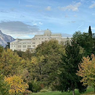
This is the image of Monte Bondone that I saw this morning from the class where I was testing my hydrology course students. 


I realized that I could have asked them to comment the hydrologic status of the hillslope they were seeing (or the geomorphology indeed). Because in these days droughts it is hitting. The argument could be that one.  So let take the Figure above and trace some lines as below. 


If you follow line one, better seen in the initial figure, you can see mostly conifers and probably some beech tree. Their color is dark and they are in little valley-hollow. The plants there are not probably under stress. Same as along most of line 3 which follows in the first part a convex-divergent topography  but probably in the first part there is still enough soil humidity (a closer check would be necessary though) while in the second part there is a concave, convex topography which is markedly green, and not apparently under stress yet.  In the upper part where there are not trees, but bushes and grasses which are loosing their color and manifest the dryness of the top soil (we are in a "nose", however). 

For paths 2 on the nose, trees are essentially absent, soil shallow and "bushes" dry as well.  Path 4 has a little different topography. Only in the middle it seems dry, while in the other parts, soil should be deeper and soil moisture present enough to maintain the trees dark green. Soil deep but not too deep. Path 5 in fact is on a conoid (an alluvial fan) and trees there are markedly brown. Whilst a local check remains certainly necessary, the possible interpretation is that on the alluvial fan, composed mainly by gravel and alluvial detritus, the water infiltrates deeper and is  not that available to plants root. 

Please observe also that between 1 and 5 there is a furrow that during storms hosts a waterfall and there water is surely more present than elsewhere. 

All is fictional obviously but I bet you cannot give a better interpretation. 

Tuesday, July 12, 2022

Modelling the Thermodynamics of Glaciers

 Is it possible to predict the ice temperature and its thermodynamic properties?  In principle it would not seem difficult.  The heat propagation equation has long been known.  It therefore seems that it is enough to know the incoming solar radiation, have a simple model of heat propagation, a digital model of elevation of the glacier and the terrain, and that's it.  There are some difficulties though.  Assuming the physics works as described, we can understand fairly quickly that the heat capacity of the ice is enormous and if the mass of the glacier is large, this requires that the heat balance model must be run for hundreds of years to obtain reliable results.  This is impractical because we would need to know the (forcing) meteorological conditions starting from a distant past (everyone knows that the future is unknown, fewer are those who reflect on the fact that not even the past and the present are perfectly known).  In fact, as any mathematician knows, glacier modeling requires you to set the temperature and heat flow conditions around the glacier at any time (the boundary conditions).  We do not have them but we can invent plausible ones, making use of a little art and a lot of artisan’s experience.  This, to be honest, introduces some uncertainty into what is being built, but it would be enough to be clear about this and people could perhaps understand.
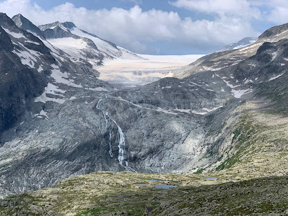

    Obviously, as you can imagine, the thermodynamics of glaciers is not as trivial as we assumed at the beginning.  It is a fact that knowledge of ice physics hasn't evolved much in the last twenty years or so.  How does snow compact into ice?  And how does ice behave under great pressure?  How does the heat capacity of ice vary during these metamorphisms?  And how the thermal conductivity?  (The first factor tells how much energy it takes to make the temperature of a kilogram of ice vary by one degree, the second how fast, the energy changes redistribute through the ice pack).  And, furthermore, what is the thermal variability of ice in space?  The action that determines these quantities is called the characterization of the thermal properties of ice.  This can be done by monitoring glaciers and making some assumptions, but it cannot be obtained without careful application.

  In reality we should not only solve the thermal balance but the whole energy balance, which includes the possible phase transitions that generate the transformation of ice into water and water vapor and, of course, vice versa.  If we make these necessary refinements, the equations become more difficult to be solved (well, some colleagues have said that for certain reasons the energy budget models are often wrong - not ours actually - due to the numerical consequences introduced by these aspects).  When liquid water is added to ice, percolation and runoff are obviously obtained, which change the nature of the phenomena and of the descriptive equations, to which the advection-dispersion terms must be added.
  Perhaps I also forgot to mention that snow is different from ice and the properties of the ground beneath the glacier are important in determining the general state of a glacier itself.
Going to the problem of the failure of the Marmolada glaciers, the failure itself is a different business because it has to deal with the formation of cracking and geo-mechanics of solids. They certainly depend on the thermodynamics but this connection itself is not easy to obtain since both the geometry of cracks and the mechanics are two further differentiated issues.

 So do we have to conclude that the hope of modeling the thermodynamics of a glacier is a lost battle?  Not at all!  We must conclude that with the investigators patient, a lot of evidence can be gathered and some results can be obtained to get a decently approximate thermal state of the glacier.  We can realize that above all it is an accumulation of information that is necessary and that this derives from the possibility of continuing research over time. Only patient application (and some intuition) eliminates the gray area in our knowledge of these problems and improves the models.  Maybe we are year zero, but next year we could be year one, and so on.

For who wants to go a little deeper on the topic they can find a little of literature below.

References

Aschwanden, Andy, Ed Bueler, Constantine Khroulev, and Heinz Blatter. 2012. “An Enthalpy Formulation for Glaciers and Ice Sheets.” Journal of Glaciology 58 (209): 441–57. https://doi.org/10.3189/2012JoG11J088.

Beniston, Martin, Daniel Farinotti, Markus Stoffel, Liss M. Andreassen, Erika Coppola, Nicolas Eckert, Adriano Fantini, et al. 2018. “The European Mountain Cryosphere: A Review of Its Current State, Trends, and Future Challenges.” The Cryosphere 12 (2): 759–94. https://doi.org/10.5194/tc-12-759-2018.

Carletti, Francesca, Adrien Michel, Francesca Casale, Alice Burri, Daniele Bocchiola, Mathias Bavay, and Michael Lehning. 2022. “A Comparison of Hydrological Models with Different Level of Complexity in Alpine Regions in the Context of Climate Change.” Hydrology and Earth System Sciences 26 (13): 3447–75. https://doi.org/10.5194/hess-26-3447-2022.

Corripio, Javier González. 2002. “Modelling the Energy Balance of High Altitude Glacierised Basins in the Central Andes.” University of Edinburgh.

Dall’Amico, M., S. Endrizzi, S. Gruber, and R. Rigon. 2011. “A Robust and Energy-Conserving Model of Freezing Variably-Saturated Soil.” The Cryosphere. https://tc.copernicus.org/articles/5/469/2011/.

Endrizzi, S., S. Gruber, M. Dall’Amico, and R. Rigon. 2014. “GEOtop 2.0: Simulating the Combined Energy and Water Balance at and below the Land Surface Accounting for Soil Freezing, Snow Cover and Terrain Effects.” Geoscientific Model Development 7 (6): 2831–57. https://doi.org/10.5194/gmd-7-2831-2014.

Gouttevin, I., M. Lehning, T. Jonas, D. Gustafsson, and M. Mölder. 2015. “A Two-Layer Canopy Model with Thermal Inertia for an Improved Snowpack Energy Balance below Needleleaf Forest (model SNOWPACK, Version 3.2.1, Revision 741).” Geoscientific Model Development 8 (8): 2379–98. https://doi.org/10.5194/gmd-8-2379-2015.

Greve, R. and Blatter, H.: Comparison of thermodynamics solvers in the polythermal ice sheet model SICOPOLIS, Polar Science, 10, 11–23, 2016

Hewitt, I. and Schoof, C.: A model for polythermal ice incorporating gravity-driven moisture transport, Journal of fluid mechanics, 797, 2016

Hanzer, Florian, Kristian Förster, Johanna Nemec, and Ulrich Strasser. 2017. “Projected Cryospheric and Hydrological Impacts of 21st Century Climate Change in the Ötztal Alps (Austria) Simulated Using a Physically Based Approach.” Hydrology and Earth System Sciences Discussions, August, 1–34. https://doi.org/10.5194/hess-2017-309.

Hock, Regine. 2005. “Glacier Melt: A Review of Processes and Their Modelling.” Progress in Physical Geography 29 (3): 362–91.

Lehning, Michael, Perry Bartelt, Bob Brown, Charles Fierz, and Pramod Satyawali. 2002. “A Physical SNOWPACK Model for the Swiss Avalanche Warning.” Cold Regions Science and Technology 35 (3): 147–67. https://doi.org/10.1016/s0165-232x(02)00073-3.

Lehning, Michael, Ingo Völksch, David Gustafsson, Tuan Anh Nguyen, Manfred Stähli, and Massimiliano Zappa. 2006. “ALPINE3D: A Detailed Model of Mountain Surface Processes and Its Application to Snow Hydrology.” Hydrological Processes, IAHS Publica, 20 (10): 2111–28. https://doi.org/10.1002/hyp.6204.

Machguth, Horst, Frank Paul, Martin Hoelzle, and Wilfried Haeberli. 2006. “Distributed Glacier Mass-Balance Modelling as an Important Component of Modern Multi-Level Glacier Monitoring.” Annals of Glaciology 43: 335–43. https://doi.org/10.3189/172756406781812285.

Pellicciotti, Francesca, Marco Carenzo, Jakob Helbing, Stefan Rimkus, and Paolo Burlando. 2009. “On the Role of Subsurface Heat Conduction in Glacier Energy-Balance Modelling.” Annals of Glaciology 50 (50): 16–24. https://doi.org/10.3189/172756409787769555.

Perona, P., and P. Burlando. 2008. “Mechanistic Interpretation of Alpine Glacierized Environments: Part 1. Model Formulation and Related Dynamical Properties.” Advances in Water Resources 31 (June): 937–47.

Tiel, Marit, Kerstin Stahl, Daphné Freudiger, and Jan Seibert. 2020. “Glaciohydrological Model Calibration and Evaluation.” WIREs Water 66 (September): 249. https://doi.org/10.1002/wat2.1483.

Tubini, Niccolò, Stephan Gruber, and Riccardo Rigon. 2021. “A Method for Solving Heat Transfer with Phase Change in Ice or Soil That Allows for Large Time Steps While Guaranteeing Energy Conservation.” The Cryosphere 15 (6): 2541–68. https://doi.org/10.5194/tc-15-2541-2021.

Vionnet, V., E. Brun, S. Morin, A. Boone, S. Faroux, P. Le Moigne, E. Martin, and J-M Willemet. 2012. “The Detailed Snowpack Scheme Crocus and Its Implementation in SURFEX v7.2.” Geoscientific Model Development 5 (3): 773–91. https://doi.org/10.5194/gmd-5-773-2012.

Weiler, Markus, Jan Seibert, and Kerstin Stahl. 2018. “Magic Components-Why Quantifying Rain, Snowmelt, and Icemelt in River Discharge Is Not Easy.” Hydrological Processes 32 (1): 160–66. https://doi.org/10.1002/hyp.11361.

Wever, N., C. Fierz, C. Mitterer, H. Hirashima, and M. Lehning. 2014. “Solving Richards Equation for Snow Improves Snowpack Meltwater Runoff Estimations in Detailed Multi-Layer Snowpack Model.” The Cryosphere 8 (1): 257–74. https://doi.org/10.5194/tc-8-257-2014.

Zemp, Michael, Wilfried Haeberli, Martin Hoelzle, and Frank Paul. 2006. “Alpine Glaciers to Disappear within Decades?” Geophysical Research Letters 33 (13): 303. https://doi.org/10.1029/2006GL026319.

Monday, July 11, 2022

Opening positions on the following Ph.D. Topics at the Hydrology group of the University of Trento (Italy) for the 2022-2025

  • Hydropower generation in the Italian Alps under a climate changing climate
  • On assimilation of radar data for improving snowmelt modelling in alpine regions
  • Building a Digital eArth Twin of Hydrology (DARTH)
  • Coupling vegetation dynamics, hydrological models, and high-resolution remote sensing data to understand onset and propagation of hydrological droughts in mountain regions
  • Hybrid Machine Learning and Process-based modeling in environmental applications
  • Adaptive blueprint: responsive landscape and infrastructures for the transition of cities and territories
The above Ph.D. positions in Hydrology and Hydro-informatics are available at the University of Trento, Department of Civil and Environmental Engineering and Center for Agricolture, Environment and Food. For each one, please find below the reference person and website indication.
The Hydrology group of UniTrento is a growing reality with six faculty members, six postdocs, and 11 international Ph.D. students (not including this call). The group has several international collaborations with University of Southern California, EPFL, Colorado State University, University of Alabama, Carleton University and others on specific topics.
Please feel free to disseminate the information to interested students worldwide. Below a more detailed description of the topics.


The DICAM Department site 

Hydropower generation in the Italian Alps under a  changing climate  (Ph.D. in Sustainable Development and Climate change, grant: CU1.13)

    Water resources are under threat by the combined effect of climate change and overexploitation for agricultural, industrial and human consumption. To gain knowledge and better inform future directions in the water sectors this research topic aims at developing a suite of models, organized as digital twins of the intertwined natural and technological systems, for simulating the complex interplay between water needs and stresses caused by climate change and the uneven distribution of water demand. In particular, the objective of this research project is to analyse the impact of climate change and the energy market on hydropower production of the Italian Alpine Region (GAR). The analysis will be conducted by means of the multi-scale hydrological model HYPERstreamHS recently developed by the Hydrology group of the University of Trento. The model will simulate the hydropower production and the associated streamflow alterations by modelling explicitly the functioning of relevant hydraulic infrastructures. 
The main research lines are the following:
  •  Scenario analyses of climate change impact on hydropower production in the Italian Alpine region including assessment of the vulnerability of the main hydropower systems. In addition, the role of reservoirs as energy storage systems complementing other renewable energy sources, namely solar and wind energy, will be investigated also in relation to climate change scenarios. Transition to pumped-storage solutions will be also considered to exploit the transfer of large water volumes in hours of relatively low electricity prices.
  • Effect on hydropower production of the evolution of the electricity market as fostered by the development of new storage technologies and projected changes in wind and solar energy production.
  • Development of tools for the analysis of the water conflicts and related mitigation strategies for enhancing the resilience of the energy-water nexus.
Required skills:

The candidate is expected to have a background in civil/environmental engineering, earth and environmental sciences or related disciplines. Furthermore, the candidate is expected to have a strong mathematical background, strong programming skills (e.g. C++, FORTRAN, Python, MATLAB) and a desire to perform modelling work within the context of the climate-water-energy nexus. Fluent spoken and written English, as well as good communication skills, are also required.


Ph.D. position on assimilation of radar data for improving snowmelt modelling in alpine regions 


Reference persons: Riccardo Rigon and Giacomo Bertoldi (giacomo.bertoldi@eurac.edu)

We are looking for a PhD candidate on the assimilation of radar remote sensing data for improving snowmelt modelling in alpine regions. The position is in the framework of the "SnowTinel" project, which aims to use Sentinel-1 SAR satellite data and catchment hydrological modelling for an improved quantification of snow-melt dynamics in alpine regions. Snowmelt is an essential component of the water balance in mountainous regions, and current climate change is altering its dynamics at a rapid rate. The recent increase in the availability of radar satellite products offers great potential to improve our ability to understand and monitor snowmelt processes with high spatial and temporal resolution. The Ph.D. will gain competences both in the fields of hydrologic modeling and of remote sensing, developing advanced integrated approaches with a significant applied impact for water resources management. The work will involve the use of state-of the art hydrological snow models over alpine catchments, their validation with field observations and the development of remote sensing radar data assimilation approaches in a pre-operational setting.

Requirements

• Master degree in engineering, statistics, meteorology, computer science, computational geography or a comparable course of study

• Willing to learn computational and programming knowledge

• Attitude to field work in mountain winter environments.

• Ability in team working, good communication, motivation to learn and personal initiative

• Good English (good German and / or Italian desirable)

• Experience with programming and data analysis software, modelling of cryosphere and hydrological processes is desirable

The position will be in collaboration with Eurac Research and the Institute for the Study of Snow and Avalanches in Davos in Switzerland. The SnowTinel project is coordinated by Eurac Research and is supported by the research partnership with the Swiss National Science Foundation (SNF) and the autonomous Province of Bolzano.

Ph.D. position on building a Digital eArth Twin of Hydrology  (DARTHs)


Reference persons: Riccardo Rigon (abouthydrology@gmail.com)
Website of the call: https://www.unitn.it/en/phd-nrrp-calls (further information coming soon on the site)

We are seeking for a pro-active individual either with a degree in environmental engineering, physics, mathematics with the will to work on the informatics infrastructure of the GEOframe/OMS3 system or someone with a degree in Informatics or Computer Science willing to mix their knowledge with the needs of Hydrology and Earth System Sciences in order to provide services to computer modelling and forecasting of hydrological quantities. The system being developed is being applied to the Po river catchments for the forecasting of droughts and the assessment of water availability and will be subsequently extended to the whole Italy.
The starting point is the project currently being developed at the basin Authority of river Po and will be based on the informatics of the GEOframe/OMS3/CSIP (Object Modelling System/Cloud Service integration platform).
The duties and the scope of the PhD work could vary according to the candidate background and attitude and can include: improvements of the workflows of the platform towards the direction to obtain a DARTH, improving the parallelism of computation in the cloud (by modifying OMS3/CSIP or using other tools like Airflow and Kubernetes), providing visual AR/VR interfaces to the workflow, cleaning the entire platform and evolve it.

In this project imagination and willing to challenge theirselves comes before than any already acquired knowledge.

The Ph.D. will be in an international context which include the participation of Colorado State University (dr. Olaf David) for OMS3/CSIP, Pisa University (dr. Marco Danelutto) for parallel computing, University of Saskatchewan (dr. Martyn Clark and dr. Wouter Knoben) for shared workflow and ourselves in Trento (dr. Riccardo Rigon, dr. Giuseppe Formetta, dr. Niccolò Tubini). We do not exclude the possibility to open further collaboration with colleagues of the University of Trento or the Trentino Research System. Besides the work will be in strict contact with the Po river basin authority for which the infrastructure will be deployed. The candidate is assumed to spend at least 6 months in Colorado State University and 6 months at the Po river basin Authority.
The interested candidate are invited to contact dr. Riccardo Rigon at abouthydrology@gmail.com. The official call is at https://www.unitn.it/en/phd-nrrp-calls
For who interested in deepening the knowledge about the Digital eArth Twins of Hydrology (DARTH) a concept paper was written for Hydrology and Earth System Science and can be found here.
The infrastructure built will be open source, built with open-source tools, openly documented by using literate programming and literate computing workflows. It will also makes it easier to share public open data, and, at the same time, getting their elaboration back. FAIR principles are already at the core of the existing infrastructure, as it can be deduced from http://abouthydrology.blogspot.com/2022/03/geoframe-essentials.html and http://abouthydrology.blogspot.com/search/label/DARTH


Coupling vegetation dynamics, hydrological models, and high-resolution remote sensing data to understand onset and propagation of hydrological droughts in mountain regions


Reference person: Giuseppe Formetta (giuseppe.formetta@unitn.it)
Website of the call: https://www.unitn.it/ateneo/663/concorso-di-ammissione?fbclid=IwAR34yKvimXKVE9Ak-Qm8eML9qZeHzRHGYjGHB4YO-7fJn91z7KlRAlc9oqQ

Alpine mountainous basins provide critical water supply and ecosystem services, yet these environments are increasingly at risk due to the combined effects of climatic change and anthropogenic stressors, i.e. competition for water across urban, agricultural and environmental demands.
In spite of the recent progress in land surface monitoring, current drought estimation in widely used operational products still largely relies on poorly parameterized potential evapotranspiration, in combination with simple hydrological bucket models (e.g., drought indices) which have shown to lead to questionable results. As hydrological systems are intrinsically intertwined with climatological and ecological systems, the propagation of meteorological droughts is modulated by a variety of mechanisms which are linked to carbon and water cycle interactions and specifically to how different plant species i) access subsurface water storages and ii) respond to water stress, high CO2 and high evaporative demand. Ignoring the parameterization of these mechanisms is often the norm in state-of-the-art land surface and hydrological models and impacts water balance closure via incorrect representation of transpiration leading to uncertainties in hydrological drought prediction.
The ultimate goal of the PhD project is to unravel the interactions between vegetation and water cycles as to understand the modulating effect of the vegetation on water-supply deficit (as opposed to the more frequently addressed meteorological drought) and its impact on water resources and natural ecosystems in mountainous regions. The work plan will focus on the Adige and the Po river basins and will employ a novel combination of field monitoring (soil water content, soil suction, meteorological measurements), remote sensing, data assimilation and ecohydrological models. The objective is to envision and implement a novel conceptual framework that will be used to translate the acquired scientific knowledge into practices to support water resources and silvopasture management.
The project is partially supported by the PRIN Waterstem – 2021-2023 and include the collaboration of the CNR-IRPI (Perugia) and EURAC.


Hybrid Machine Learning and Process-based modeling in environmental applications

Reference Person: dr. Alberto Belling (alberto.belling@unitn.it)

Modeling of natural processes has received a significant burst in the last years thanks to the escalating computational power and the availability of massive data from satellite and near surface surveys, citizen science, new sensors and from large scale modeling of climate in environmental applications. Data are also accumulating on the impact of environmental pollution on human and freshwater ecosystems health. These two paradigmatic changes paved the way to the application of Machine Learning techniques in sectors, such as that of water resources and environmental pollution, traditionally addressed with process-based models and also plagued by data scarcity. One of the main challenges of environmental modeling is the need to represent complex phenomena with limited data availability and this increases uncertainty in modeling response, including unknown uncertainty, i.e. uncertainty that exists but cannot be identified (see Rubin et al., 2018). Uncertainty is unavoidable in modeling natural processes and it originates from two sources: the heterogeneity of the media or the environment in which the processes occurs and the inability of the model to fully capture process dynamics. Better parametrizations of the physical processes may alleviate the impact of the second source of uncertainty, but the first one is difficult to handle due to our limited ability to model the disordered spatial variability of media properties. The progressive increase of data availability and the development of data-driven methods open new perspectives in handling uncertainty in modeling natural processes and their interplay with the human activities. A large body of literature is available on the impact of uncertainty on the process-based models, but much less in the data-driven approach traditionally developed in fields in which the question to answer was simple with respect to the complexity and richness of the underlying processes, and in most cases representing the process leading to the observed complexity was not an objective of the analysis, as in image interpretation for example. In this case, uncertainty in the underlaying processes does not affect, or exerts a limited influence, the answer the modeler is seeking. Unfortunately, this is not the case in environmental applications, where the interest is on the full dynamics, which is decisively impacted by uncertainty. The research will focus on the different evolutions of the Neural Networks and will be developed along two main directions: 1) the inclusion of physical constraints into the ML algorithms with the objective of excluding unphysical connections among the neurons and the development of new activation functions compatible with the process under investigation; 2) development of hybrid models taking advantage of the capability to learn from the data of the ML algorithms and the respect of physical constraints typical of process-based approaches. The research will be conducted in one or more of the following areas: 1) Impact of water (over)exploitation and climate change on subsurface (groundwater) water resources. Here a hybrid model combining the capability of process-based models with data-driven approaches is expected to provide enhanced modeling capabilities and provide reliable estimates of groundwater resources. Groundwater is indeed a critical water resources, which is endangered by overexploitation and contamination; 2) Risk analysis and impact on human health of environmental contamination. This class of models are intended to identify the nexus between pollution indicators (possibly simple to determine) and human health in impacted areas. High levels of contamination with the most relevant impact on human health occur often at specific locations (hot spots) and specific time (hot moments) and identifying them requires new modeling paradigms; 3) Modeling the interplay between the different renewable energies and their effect on the timing of hydropower production leading to streamflow alteration. This theme is relevant because the energy crisis and the progressive transition to renewable energy sources is causing a boom of new hydropower systems with adverse effects on the streamflow and freshwater ecosystems that are expected to be relevant and for this reason they need to be explored. In the presence of significant alterations of the natural regime due to hydropower exploitation process- 2 based models show typically low performances, while data-driven approaches are more flexible and may help in identifying unknown nexuses among the data and provide new visions in this important energy compartment.

There is actually a sixth position:

Adaptive blueprint: responsive landscape and infrastructures for the transition of cities and territories (PhD Position Curriculum D - Architecture and Planning, Landscape at the Dept. of Civil, Environmental and Mechanical Engineering - University of Trento)

Reference persons: Sara Favargiotti (sara.favargiotti@unitn.it), Alessandra Marzadri (alessandra.marzadri@unitn.it)
Participant: Mathilde Marengo IAAC (Institute for Advanced Architecture of Catalonia).


Short description of the position/project: “Adaptive blueprint” wants to propose a PhD activity to train an interdisciplinary figure capable to manage innovative, interdisciplinary strategies for urban planning, integrating the aspects of biodiversity conservation, ecological connectivity with aspects related to the quantity and the quality of the water resource. Expected outcomes of the PhD activity can be listed as follows: 1) design and model, in different territorial areas, new intervention strategies aimed at maximizing their efficiency in reducing climate change effects; 2) develop new knowledge in the field of sensing systems to be applied to NBS to implement software systems that allow remote mapping, design and control of their efficiency in water management and to improve the collective well-being and the ecosystem services; 3) development of an integrated design strategy: landscape analysis + design and software implementation + sensing systems to evaluate the multiple benefits and effects of NBS at different spatial (i.e. single building or open spaces) and temporal scales. 
Expected results: of this PhD scholarship are extremely innovative and in line with the objectives and purposes of the REACT EU and the new themes envisaged in the European Green Deal. The position is intended to be co-tutored with dr. Mathilde Marengo with a research period abroad at the IAAC - Institute for Advanced Architecture of Catalonia in Barcelona.

Requirements: 
  • Master degree in Architecture and Planning, Landscapes, Civil or Environmental Engineering or  comparable course of study; 
  • Possess strong spatial design expertise and knowledge of GIS techniques (e.g. GRASS and QGIS) and of landscape representation (e.g. AutoCAD, Photoshop, Illustrator, InDesign or similar Open Source software e.g. GIMP); 
  • Ability to work independently and as part of a team, self-motivation, adaptability, and a positive attitude; 
  • Good English (good Italian desirable); 
  • Experience with programming and model development (or willing to pursue them).