Showing posts with label WHETGEO. Show all posts

Thursday, February 6, 2025

Biosphere, Atmosphere, Climate Interactions 2025 Class


The second part of this course explores the Soil-Plant-Atmosphere Continuum (SPAC). Below you will find materials covering soil properties, their mathematical representations, and an introduction to plant functioning. Students are expected to review these materials as an assignment before our class discussion of the concepts. In the latter portion of the course, we will conduct numerical experiments together using the GEOSPACE system.


Radiation

Water in soils 
 (Storyboard2020)
Once precipitations arrive to the ground surface they either infiltrate or generate runoff. We first state how they infiltrate and, actually how water behave in the soil and in the ground. We talk about the complexity of the Earth surface that contains life and call it, the Critical Zone. To study infiltration we introduce the Darcy and Richards equations of which we explain the characteristics.
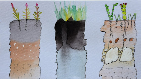
  • A deeper view on matric potential 

Evaporation generalities (Storyboard2020)

A consistent part of root zone and surface water evaporates and returns to the atmosphere to eventually form clouds and precipitation again. The process follows quite complicate routes and is different when happening from liquid surfaces, soil or vegetation (and BTW animals).  In this group of lectures we try to figure out the physical mechanisms that act in the process and give some hint on methods to estimate evaporation and transpiration with physically based models. 
  • Supplemental Material
A little on the carbon cycle

The carbon cycle is intrinsically and fundamentally intertwined with both hydrological and climate cycles, forming an interconnected web of Earth system processes that operate across multiple temporal and spatial scales. While carbon dynamics were historically studied as a separate discipline from hydrology and meteorology, this artificial separation has dissolved as hydrology and meteorology have evolved into a comprehensive Earth System Science that recognizes the profound interconnectedness of all planetary processes. The integration of carbon cycle studies with hydrology represents a paradigm shift in our understanding of how Earth's systems function. Water serves as the primary medium through which carbon moves between the atmosphere, biosphere, hydrosphere, and geosphere, while carbon dynamics simultaneously influence water availability, quality, and distribution patterns. This bidirectional relationship creates a complex network of feedbacks that are not merely numerous, but virtually countless in their manifestations and interactions.


Further Reading

D’Amato, Concetta, and Riccardo Rigon. 2025. “Elementary Mathematics Can Help to Shed Light on the Transpiration Budget under Water Stress,” January. https://doi.org/10.1002/ECO70009.


Monday, April 29, 2024

Exploring the Soil-Plant-Atmosphere Continuum: Advancements, Integrated Modeling and Ecohydrological Insights, a Ph.D. Thesis by C. D'Amato

This thesis aims to address the complex issue of SPA interactions by developing a comprehensive set of models capable of representing the intricate dynamics of this system. At the core of this research lies the integration of sophisticated descriptions of hydrological and plant biochemical processes into a novel ecohydrological model, GEOSPACE-1D (Soil Plant Atmosphere Continuum Estimator model in GEOframe).


Through a combination of theoretical exploration, engineering methodologies, and empirical experiments, this thesis aims to advance our understanding of SPA interactions. The development of adaptable models, represents a significant contribution to the field. The thesis emphasizes the practical implications of employing models to analyze experimental data, thereby enhancing our comprehension of various phenomena.

In conclusion, this thesis provides valuable insights into SPA interactions and lays the groundwork for future research and applications. By embracing the challenge of under- standing and modeling the SPA continuum, this work contributes to the ongoing efforts to address environmental challenges and promote sustainable practices.  The thesis draft can be dowloaded by clicking on the figure. 


Sunday, November 6, 2022

(Inter)active WHETGEO 2D Poster for the Italian Hydrological Meeting 2022 in Genova (Italy)

Because I am usually bored of repeating things, I tried here to renovate the poster experience. The poster itself can be done much more attractively, I guess. However, I added several QR codes that send the reader to videos which comment any part of it.  These videos, in turn are part of a presentation that is also included below.  The poster is intended to illustrate the content of research work and implementation that is currently in a pre-print form, submitted to the Environmental Modelling and Software journal (available at the previous link). 

  • The poster itself is here.
  • The presentation that explains the poster is here. 
  • The videos showcase is here.
The good of the poster experience is that if you resolve the QR codes with a mobile you have right away the video explanations. 

Tuesday, August 9, 2022

WHETGEO-2D an open source tool for solving the 2D Richards equation

For new readers, WHETGEO stands for Water HEat and Transport in GEOframe. It is a set of models that deals with the processes in soils. The paper describes the 2D version of it, at least its initial deployment, since the system was built on the idea of expandability. The paper and its abundant supporting material a a step towards a series of further analyses of  the water behaviour in the vadose and saturated zones.

DeAnn Presley painting (https://www.agronomy.k-state.edu/about/people/faculty/presley-deann/)
The paper was submitted to environmental Modelling and Software and can be found  here.  Extensive material and video about WHETGEO 2D can be found among the material of the GEOframe Summer School


Sunday, January 9, 2022

WHETGEO essentials

Water, HEat and Transport in GEOframe  (WH?ETGEO) is the set of components which was conceived and developed to substitute GEOtop. It with GEO-SPACE more precisely. Its design is more complex than GEOtop, since it includes various modelling solutions, 1D, 2D, 3D (coming soon) and additional processes can be added without large efforts. 2D and 3D versions can work with an unstructured grids and there is a lot of flexibility to be exploited to pursue new ideas that were not even conceivable with GEOtop. 


At present the best presentations of the models and the ideas are obtained by reading the Niccolò Tubini Ph.D. Thesis and the paper on GMD just published. WHETGEO + GEOSPACE have a dedicated summer school whose 1st edition was celebrated recently.  The index of GEOframe Schools can be found here.

Other contributions will come soon. 

References

Tubini, N. 2021, June. “Theoretical and Numerical Tools for Studying the Critical Zone from Plots to Catchments.” Edited by R. Rigon and S. Gruber. Ph.D., Dipartimento di Ingegneria Civile, Ambientale e Meccanica, Università di Trento.

Tubini, Niccolò, and Riccardo Rigon. 2022. “Implementing the Water, HEat and Transport Model in GEOframe (WHETGEO-1D v.1.0): Algorithms, Informatics, Design Patterns, Open Science Features, and 1D Deployment.” Geoscientific Model Development 15 (1): 75–104. http://dx.doi.org/10.5194/gmd-15-75-2022

Saturday, June 5, 2021

Theoretical and Numerical Tools for Studying the Critical Zone from Plots to Catchments

 What a valuable work is the thesis by Niccolò Tubini, here presented in its draft.  It covers works in hydrology of the critical zone, numerics, programming, software engineering, open science methods. Having a so wide horizon of interest it could  not be easy to grasp in all of these details, but it is well written and, we hope inspiring. As the Author, Ph.D. candidate says: "In the following we suggest that studying the CZ requires tools that are not yet readily available to researchers; then we propose one of our own. These tools should be flexible enough to allow the quick embedding of advancements in science"

Who wants to access the draft, can click on the figure of the Thesis first page below.

The Thesis included the work present in the two submitted paper by Niccolò,  on The Cryosphere and a second one presented in GMDD regarding WHETGEO-1D.  Whilst a thesis being considered kind of a definitive work, this one remains very much a work in progress with the extensions of the codes foreseen to arrive soon and whose informatics has already been implemented. All the tools developed during the Thesis are open source and freely available both as executable and source codes on Github.  Any comment or suggestion to the  Thesis as well as to the papers are welcomed. 

The Video of the defense is here.

Wednesday, May 19, 2021

WHETGEO 1D is out

WHETGEO-1D (Water HEat and Transport in GEOframe) is a physically based model simulating the water and energy budgets in a soil column. WHETGEO-1D is developed as an open-source code, adopting the Object-Oriented paradigm and a generic programming approach to improve its usability and expandability. WHETGEO-1D is fully integrated in the GEOframe/OMS3 system allowing the use of the many ancillary tools it provides. It comes on top of several years of work on engineering software, discussing and debating about Richards equation, taking care of getting appropriate integration methods in a travel that crossed hydrology, mathematics, numerics and software engineering.  Click on the figure below to access the paper.


The code is really solid and was throughly tested over the last three year by my students of the Hydrology class and in various applications. Its inputs and outputs can be analyzed by using Python and some standard Notebooks prepared to help the user to do it.  The paper has been submitted to the Geoscientific model development discussions (GMDD) and it is available for discussion to everyone and can be obtained by clicking on the Figure above. Complementary material is present in the GEOframe blog. The paper comes with its software, documentations and test and the GEOframe blog post explains where all of it is. You did a nice job Niccolò Tubini!

Here the paper on GMD.

Wednesday, March 24, 2021

4 Lysimeter GEO users

  In ten minutes or so I am meeting the first organised group of possible Lysimeter GEO users that are not just my students of the Hydrology Class. It is time, I guess for collecting all the material we organised around it.  Lysimeter GEO is the informatics companion of a real Lysimeter, like the one in Figure.

Installations should follow the standards of the GEOframe systems (edition Rossano in these days)

I assume that Richards theory is known. Otherwise, one should give a look to this old but still valid presentation (if English speaking). Otherwise the most recent class of Hydrology can be useful for this learning task. You can find it here.

Figure is from Nehemy, et al. 2020. “Tree Water Deficit and Dynamic Source Water Partitioning.”  https://doi.org/10.1002/hyp.14004.


Lysimeter GEO uses WHETGEO 1D (the creature of Niccolò Tubini) for estimating infiltration in waters. Information on how using WHETGEO can be found in the lab classes of the Hydrology course (unfortunately  the video material is in Italian but, all the documentation provided trough Jupyter Notebooks is in English. Particularly relevant, when you go to download the code (see below) is giving a look to the Notebook_Zero which give the general information.  A paper on WHETGEO is in the process of writing. As soon as we will have a decent draft, it will be shared with people on this and other posts. 

Lysimeter GEO currently implements the Priestley-Taylor, Penman-Monteith-FAO and the Prospero model for the estimation of evapotranspiration. All of them are well documented in Michele's (Bottazzi) Ph.D. Thesis. It is producing some publications too, and when they will be in preprint, they will be shared. Applications of the GEOframe models of evapotranspiration are available at the GEOframe Winter School pages (here). 

All of it is put together with the Lysimeter GEO model. Concetta D'Amato prepared a couple of seminar for its use which are available at this WATZON project page. The code and material used by Concetta in her presentation is available here.

All of us is committed to promote the use of our tools. Everything is open source, well designed, well documented. Do not esitate to ask us for support, if needed. WHETGEO, Prospero and Lysimeter GEO are on Github. 

Wednesday, December 23, 2020

Lysimiter GEO - Webinar II - An exercise step by step

 This follows the first webinar on Lysimeter Pro, a GEOframe modelling solution intended to estimate the 1D soil-vegetation-atmosphere fluxes using the GEOframe WHETGEO and GEOframe Prospero tools. No more explanations are required than those you already find in the previous webinar and in the Jupyter Notebooks inside the  OMS3 project at here. The OMS project contains all the executable, however you have to do some installations before using the GEOframe working environment

Please find the video of the webinar below.

Executing Lysimeter GEO from Ri Rigon on Vimeo.

The previous webinar here.  For any question please do not exitate to contact us using the GEOframe users google group: https://groups.google.com/g/geoframe-components-users

Friday, December 18, 2020

Lysimiter GEO - Webinar I

 Land-Vegetation-Atmosphere interactions are an exciting field of Hydrology. Within our system GEOframe, one branch of work is improving the physics of GEOtop and this talk shows some of the work we made to this goal. Lysimiter GEO builds a virtual lysimiter and modeling infiltration and energy transfer in soil and evaporation and transpiration. The infiltration is modeled by the component WHETGEO 1D (Water, HEat and Transport in GEOframe) that integrates the 1D Richards developed by Niccolò Tubini. The evaporation and Transpiration are modeled by the GEOframe component Prospero  developed by Michele Bottazzi  in his Ph.D. Thesis.  Lysimeter GEO, however, was completed by Concetta D'Amato who is pursuing her Ph.D. on these topics within the PRIN project WATZON.By clicking on the Figure below you can access the slides. 

If you want to run Lysimeter GEO, you have first to install the GEOframe 2021 environment.  Here below, please find the video of the talk.  The OMS project for all the run can be found on OSF here


The second webinar containing an exercise did step by step is in this new post.