Showing posts with label Global Hydrological Data. Show all posts

Thursday, December 24, 2015

Two up-to-date contributions on Global Hydrology

I talk about global hydrology in a recent post. But, the topic is hot, and you do not have the time to relax, and a couple of authoritative papers are published on the global energy budget and the global water budget in the first slice of this century* **. Scientists never sleep.


L’Ecuyer, T. S., Beaudoing, H. K., Rodell, M., Olson, W., Lin, B., Kato, S., et al. (2015). The Observed State of the Energy Budget in the Early Twenty-First Century. Journal of Climate, 28(21), 8319–8346. http://doi.org/10.1175/JCLI-D-14-00556.1

M. Rodell, H.K. Beaudoing, T.S. L’Ecuyer, W.S. Olson J.S. Famiglietti, P.R. Houser, R. Adler, M.G. Bosilovich, C.A. Clayson, D. Chambers, E. Clark, E.J. Fetzer, X. Gao, G. Gu, K. Hilburn, G.J. Huffman, D.P. Lettenmaier, W.T. Liu, F.R. Robertson, C.A. Schlosser, J. Sheffield, and E.F. Wood
 (2015). The observed state of the water cycle in the early 21st century. Journal of Climate, 28 (21), 1–80.

*An update:

Please also see this recent paper on Nature Geosciences, brought to my attention by Wuletawu Abera, on the groundwaters amount:

Gleeson, T., Befus, K. M., Jasechko, S., Luijendijk, E., & Cardenas, M. B. (2015). The global volume and distribution of modern groundwater. Nature Geoscience, 1–10. http://doi.org/10.1038/ngeo2590


** A further update:

Zhang Y., PanM., Wood E.F., On Creating Global Gridded Terrestrial Water Budget Estimates from Satellite Remote Sensing, Surveys in Geophysics, DOI 10.1007/s10712-015-9354-y, 1-20, 2016

*** Yet another update

Bierkens, M. F. P. (2015), Global hydrology 2015: State, trends, and directions, Water Resour. Res., 51,4923–4947, doi:10.1002/2015WR017173.

Friday, October 12, 2012

Water Scarcity

Water scarcity is a reality for large populations in the World, and several projects started to understand it and to provide solutions.
Also regions where water is usually abundant suffer the threats of climate change and could be subject and conflicts about waters uses.
Today I was informed of the Glowasis blog   where many information are collected on the subject.

Tuesday, January 3, 2012

Flood Observatory at University of Colorado, Boulder


The information comes directly from their site, and data were obtained mostly by using remote sensing data from MODIS. In fact, The Flood Observatory uses orbital remote sensing to detect, measure, and map surface water changes. It includes:


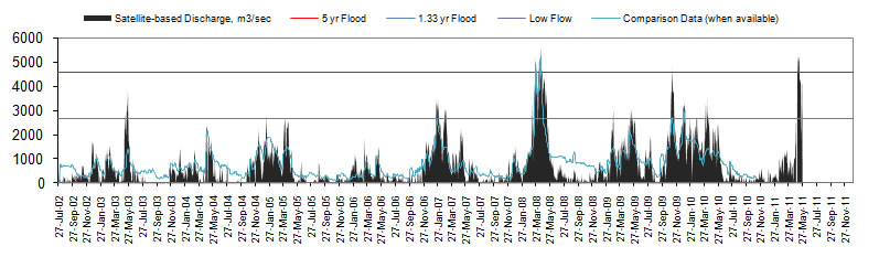
1- River Watch, an experimental satellite-based river discharge measurement system (example).

2 - The Surface Water Record, a comprehensive map record of the Earth's changing surface water.

3 - Active Archive of Large Floods, 1985 to present (listing and characterization of large flood events).


4 - Rapid Response Inundation Maps, for individual flood events.

Saturday, December 31, 2011

Free GIS Data

This is indeed a very strange blog. All feed up the same day, February 18, 2011 with 54 post about various data set. Two at least did not escape my attention.

The global Evapotranspiration map made by Antonio Trabucco  for the CGIAR-CSI :

Also the reference to the global DEM derived from the satellite Aster measurements is of interest for hydrologists, and according to some paper are better than SRTM data.

These are not the only good data you can find there!

Two other source of information about GIS data are remarkable:  those from Robert T Wilson and those one can find in Tomislav Hengl wiki Spatial-Analyst at the page of global data sets.  Another source of interesting data is here where you can find addresse a map of runoff data by NCAR/UCAR and some interesting considerations.